Ballycastle, County Mayo
| Ballycastle Baile an Chaisil | |
|---|---|
| Town | |
 Ballycastle Location in Ireland | |
| Coordinates: 54°17′00″N 9°22′00″W / 54.2833°N 9.3667°WCoordinates: 54°17′00″N 9°22′00″W / 54.2833°N 9.3667°W | |
| Country | Ireland |
| Province | Connacht |
| County | County Mayo |
| Elevation | 78 m (256 ft) |
| Population (2002) | |
| • Town |
Dún Briste Dún Briste The Sea Stack known as 'Dún Briste' (The Broken Fort) can be seen at Downpatrick Head, 3 miles north of Ballycastle. It was separated from the mainland in 1,393 as a result of high seas and the people were taken off using ships ropes. It is 63 metres by 23 metres, 45 metres high and 228 metres from the shore. According to one legend, a pagan chieftain, named Crom Dubh, lived there. He refused to listen to St. Patrick who tried to convert him to Christianity. St. Patrick hit the ground with his crozier and the stack was separated from the mainland, leaving Crom Dubh to die there. On July 31st 1,980, Dr. Seamus Caulfield, his father Patrick Caulfield and Martin Downes, Professor of Biology at Maynooth College, landed by helicopter on Dún Briste and spent two hours there examining the remains of the building and plant life. They discovered the remains of a stone building across the centre measuring 30ft by 13ft inside and built up along the south of a long continuous wall. The remains of another building 20ft by 10ft were on the western side. An interesting feature found there was a low opening about 2ft square, exactly like the sheep runs which can be found in many places which allow sheep to pass from one field to another. Downpatrick Head Downpatrick Head 3 miles north of Ballycastle village is a striking headland standing 126ft above the sea. From here, there are fantastic views of the Atlantic, the Staggs of Broadhaven to the west, and high cliffs along the shore. The small stone building at the top of Downpatrick Head was used as a lookout post during the Second World War. It is now used to view the many species of birds on 'Dún Briste'. The ruins of a church, a holy well, and a stone cross mark the site of an earlier church founded by St. Patrick. Pilgrims visited Downpatrick Head on the last Sunday of July - 'Garland Sunday'. Mass is now celebrated on Downpatrick Head on this day. The old statue of St. Patrick was erected here in 1,912 and this was replaced by a new statue in the early 1,980s. Here also, you see the spectacular blow-hole known as 'Poll na Seantainne' with subterranean channel to the sea, where 25 men lost their lives in the aftermath of the 1,798 rebellion. They are said to have taken refuge on the ledge at the bottom, and the tide came in before the ladder could be replaced. One of the sites on the Tír Sáile Sculpture Trail, called 'Battling Forces', is located here. |
| • Urban | 249 |
| Time zone | WET (UTC+0) |
| • Summer (DST) | IST (WEST) (UTC-1) |
| Irish Grid Reference | G104378 |
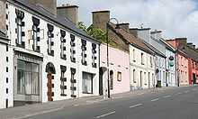
Ballycastle (Irish: Baile an Chaisil, meaning "town of the castle") is a village in County Mayo, Ireland, situated northwest from Ballina, near Mayo's north coast in the West of Ireland. Ballycastle is also on the edge of an Irish speaking area called a Gaeltacht.
Ballycastle is situated on the rugged coast of North Mayo, with its northern boundary exposed to the wild Atlantic ocean. To the west of the town are the Stags of Broadhaven, to the east lies Killala Bay while to the south are the towns of Crossmolina and Ballina. It was at the Céide Fields that the first settlers began to farm the slopes of the Behy/Glenurla hillside over 5000 years ago. Ballycastle is host to the annual Healyfest festival. The festival takes place every August Bank holiday weekend and has grown from strength to strength since its inception in 2005. This event attracts bands from all over Ireland and beyond for a weekend of great fun and great music.[1]
The area covered by the present parish of Ballycastle is roughly that known as 'The Lagan' in the old Irish records. The Lagan comprised the valley or hollow tract of land, which is surrounded on the East by the Hill of Kilbride, on the South by Athleague Hill, then to a range of hills as far as Ballinglen, to the sea which formed its northern boundary. From its natural appearance, the area got the name of 'The Lagan' or 'Little Hollow' The older parishes of Doonfeeney & Kilbride amalgamated in 1804 to form the present day parish of Ballycastle. Until then, Ballycastle was just a townland in the parish of Doonfeeney. The name Ballycastle was in use by about 1470. From Staffords survey, we know that the town was founded in 1797 on the property of John Knox Esq. of Castlereagh. Thomas Palmer Esq. Summerhill, held it on lease and sublet the ground to the inhabitants of Ballycastle by leases of one life at 40 shillings per acre. The town consisted of 82 houses built of stone. The Church of Ireland was built in 1827 and the Catholic Church in 1828. The present day Church, St. Brigid's, was built in 1931. Lewis Topographical Dictionary (1837), tells us that many new houses had been built; that a market place was in the course of construction; that a new line of road was being built to Belmullet; that there were petty sessions every Wednesday; that it was a constabulary and chief revenue-Police Station and had six fairs in the year and a penny post to Killala. There was also a Coastguard Station over the present day pier. During the famine Ballycastle suffered very badly. Sixty seven people died in Ballycastle. At this time, St. John's Hall was built as a soup kitchen. In 1881, a Model Farm was established by the Edinburgh Ladies Society. It was run by the Presbyterian Church and consisted of about 230 acres. Its main aim was to educate boys in better farming techniques and girls in domestic crafts. Ballycastle, because of its situation on the coast, formed a natural travel route from Ballina to Belmullet. Access to Crossmolina was afforded up the Glen Road. This led to the establishment of a market town. However, widespread use of the motor car and the opening of the mart in Ballina in the 1950s caused Ballycastle to decline. To reflect the fall in population, Kilbride school closed in 1956, Glenurla school in 1965 and Killeen school in 1969. The remaining pupils from the three schools were provided with a school bus to Ballycastle. In the 1970s, the area was being promoted as a tourist attraction. Ballycastle celebrated its Bicentennial in 1997. On 10 August, President Mary Robinson officially opened the Centre of the Ballinglen Arts Foundation. She also closed the 10 day festival and planted a yew tree in the church grounds. 1974: The holiday cottages were built. 1979: A new Health Centre was built and a new premises for the Fire Brigade. The landmark thatch cottage belonging to Tommy Loughney at the junction of Main Street and the Glen Road was demolished for road widening. 1985: The first 24 houses in Seaview Estate were built by Mayo County Council. 1992: A new National School was built and the Céide Fields Centre opened. 1995: Ballycastle/Belderrig Development Co. Ltd was set up. 1996: Four more houses were added in Seaview Estate. 1998: Great improvements take place in the town such as: replacement of water mains, installation of sewage piping, ESB cables laid underground and provision of new street lighting. 1999: Eight more houses built in Seaview Estate and The Resource Centre was opened. 2000: Stella Maris Secondary School/Convent closed in June 2000 and the remaining Mercy Nuns left Ballycastle.
Dún Briste
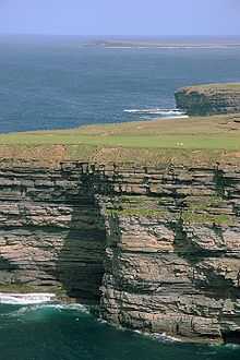
Dún Briste The Sea Stack known as 'Dún Briste' (The Broken Fort) can be seen at Downpatrick Head, 3 miles north of Ballycastle. It was separated from the mainland in 1393 as a result of high seas and the people were taken off using ships ropes. It is 63 metres by 23 metres, 45 metres high and 228 metres from the shore.
According to one legend, a pagan chieftain, named Crom Dubh, lived there. He refused to listen to St. Patrick who tried to convert him to Christianity. St. Patrick hit the ground with his crozier and the stack was separated from the mainland, leaving Crom Dubh to die there.
On July 31, 1980, Dr. Seamus Caulfield, his father Patrick Caulfield and Martin Downes, Professor of Biology at Maynooth College, landed by helicopter on Dún Briste and spent two hours there examining the remains of the building and plant life. They discovered the remains of a stone building across the centre measuring 30 ft by 13 ft inside and built up along the south of a long continuous wall. The remains of another building 20 ft by 10 ft were on the western side. An interesting feature found there was a low opening about 2 ft square, exactly like the sheep runs which can be found in many places which allow sheep to pass from one field to another.
Downpatrick Head
Downpatrick Head 3 miles north of Ballycastle village is a striking headland standing 126 ft above the sea. From here, there are fantastic views of the Atlantic, the Staggs of Broadhaven to the west, and high cliffs along the shore. The small stone building at the top of Downpatrick Head was used as a lookout post during the Second World War. It is now used to view the many species of birds on 'Dún Briste'.
The ruins of a church, a holy well, and a stone cross mark the site of an earlier church founded by St. Patrick. Pilgrims visited Downpatrick Head on the last Sunday of July - 'Garland Sunday'. Mass is now celebrated on Downpatrick Head on this day. The old statue of St. Patrick was erected here in 1912 and this was replaced by a new statue in the early 1980s.
Here also, you see the spectacular blow-hole known as 'Poll na Seantainne' with subterranean channel to the sea, where 25 men lost their lives in the aftermath of the 1798 rebellion. They are said to have taken refuge on the ledge at the bottom, and the tide came in before the ladder could be replaced.
One of the sites on the Tír Sáile Sculpture Trail, called 'Battling Forces', is located here.
Giro de Baile Cycing Sportive The Annual Giro de Baile takes place on Sun of the August Bank Holiday Weekend from Main Street, Ballycastle, Co Mayo
The Giro de Baile has quickly established itself as one of cycling best events, and ’a must do’.
You are sure to experience a magical sportive combined with post event entertainment, live music at Healyest.
The Giro de Baile is set against the stunning backdrop of the Wild Atlantic Way. The course sweeps through the quiet country roads taking in some challenging but short hills and breath-taking views. With typical rural Ireland Quiet Pace and with very few cars you will be able to enjoy the spectacular scenery in peace.
The event is open to a wide range of riders and abilities with 3 route options. 130 km 60 km and 10 km
The spectacular scenery of Ballycastle,North Mayo and Erris combined with wild animals and picturesque villages make this a truly special sportive!
The Céide Fields Ballycastle (Irish: Achaidh Chéide, meaning "flat topped hill fields") is an archaeological site is about 8 kilometres northwest of Ballycastle. The site is the most extensive Neolithic site in the world and contains the oldest known field systems in the world.Using various dating methods, it was discovered that the creation and development of the Céide Fields goes back some five and a half thousand years.

Public transport
Bus Éireann route 445 serves Ballycastle Mondays to Fridays inclusive providing a few services to/from Ballina via Killala.[2]
History

The parish of Ballycastle is a combination of the two ancient parishes of Kilbride and Doonfeeney. The name Ballycastle was in use as early as 1470 and was referred to as a parish in the Catholic directory of 1836.[3]
Famous people from Ballycastle include the Gaelic footballer Tommy Langan. He won two All-Ireland Senior Football Championships with the Mayo GAA senior county team and was named on the Football Team of the Millennium.[4]
See also
- List of towns and villages in Ireland
References
- ↑ Healyfest. WesternPeople. Accessed March 12, 2012.
- ↑ http://www.buseireann.ie/inner.php?id=247#Mayo
- ↑ Ballycastle Website. Causeway Coastal Route. Accessed March 12, 2012.
- ↑ Ballycastle in County Mayo in the West of Ireland. mayo.ireland.ie. Accessed March 12, 2012.
