Bald Mountain (Utah)
| Bald Mountain | |
|---|---|
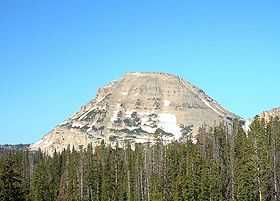 The east face of Bald Mountain. | |
| Elevation | 11,943 ft (3,640 m)[1] |
| Prominence | 1,823 ft (556 m)[1] |
| Location | |
 Bald Mountain Duchesne / Summit counties, Utah, U.S. | |
| Range | Uinta Mountains |
| Coordinates | 40°41′56″N 110°54′09″W / 40.6988354°N 110.9023931°WCoordinates: 40°41′56″N 110°54′09″W / 40.6988354°N 110.9023931°W[2] |
| Topo map | USGS Mirror Lake |
| Climbing | |
| Easiest route | Hike |
Bald Mountain is a peak in the western Uinta Mountain Range. It is an easy hike from Bald Mountain Pass and has spectacular views of the surrounding areas. The mountain is home to mountain goats, pika, and many species of wildflowers.
Because Bald Mountain is a relatively easy hike, it is among the most popular major mountain hikes in Utah. The hike to the summit can be completed in 2 to 3 hours round trip. The trail gains 1,250 feet (381 m) of elevation in 2 miles (3 km). As in any high-altitude adventure, plan this trek for early in the day to avoid afternoon thundershowers and life-threatening lightning. The route contains no real obstacles, although the presence of snow along the southern ridge, about 1 mile (2 km) into the hike, can frustrate and turn back hikers unfamiliar with traversing steep snow. When snow is not present, hikers of all abilities should have little problem with this route.[3]
References
- ↑ 1.0 1.1 "Bald Mountain, Utah". Peakbagger.com. Retrieved 2009-01-23.
- ↑ "Bald Mountain". Geographic Names Information System. United States Geological Survey. Retrieved 2009-01-23.
- ↑ Activities include hiking,camping,and canoeing in the beautiful lakes. "Bald Mountain". Uinta Mountains. Climb-Utah.com. Retrieved 2009-01-23.
External links
- Mirror Lake quadrangle, Utah (Map). 1:24000. 7.5 Minute Topographic. USGS. Retrieved 2009-01-23.
- "Bald Mountain Uintas". UtahPictures.com. Archived from the original on 8 February 2009. Retrieved 2009-01-23.