Balclutha, New Zealand
| Balclutha | |
|---|---|
| Town | |
|
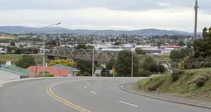
Looking across the Clutha towards the town centre. The distinctive road bridge is visible in the centre of the picture | |
 Balclutha Location of Balclutha within New Zealand | |
| Coordinates: 46°14′S 169°45′E / 46.233°S 169.750°ECoordinates: 46°14′S 169°45′E / 46.233°S 169.750°E | |
| Country | New Zealand |
| Region | Otago |
| Territorial authority | Clutha District |
| Population (2013 census)[1] | |
| • Total | 3,918 |
| Time zone | NZST (UTC+12) |
| • Summer (DST) | NZDT (UTC+13) |
Balclutha is a town in Otago, it lies towards the end of the Clutha River on the east coast of the South Island of New Zealand. It is about halfway between Dunedin and Invercargill on the Main South Line railway, State Highway 1 and the Southern Scenic Route. Balclutha has a population of 3918 (2013 census), and is the largest town in South Otago.
The Clutha District Council is based in Balclutha.
The major service center for the fertile farming region around the lower reaches of the Clutha River, it is also the nearest large town to the Catlins, a scenic region of native forest, wildlife, and rugged coastline.
Origins
Known locally as "Clutha", Balclutha's name - and that of the river on which it stands - reflects the Scottish origin of the town's settlement. The name comes from Scottish Gaelic and would be spelt Baile Cluaidh in that language; this translates into English as "Town on the Clyde".
James McNeil from Bonn Hill, Dumbartonshire, Scotland, who is regarded as the town's founding father, arrived in 1853 - via Port Chalmers, NZ in 1849. His farm was on the site of the present town, where he and the Provincial Government established a ferry service across the Clutha in 1857; as a result the town was initially called Clutha Ferry.
The Māori name for the area is Iwikatea, literally "Bleached bones" (a local Māori tribal battle in 1750 left the decomposing bodies of the defeated, their bones whitened in the sun).
Landmarks
The Clutha flows through the town. The Clutha River is the largest river in New Zealand by volume of water, and the country's second longest after the Waikato. It provides the town with various recreational facilities, including fishing (brown trout), water skiing and power boating.

The most prominent structure in the town is the concrete Balclutha Road Bridge across the river, which was built in 1935, - the initial 1868 wooden bridge was washed away on 14 October 1878. Rebuilt in 1881, it was later considered unsuitable for motor vehicles.
The South Island Main Trunk Railway crosses the river some 800 metres downstream, near the junction where the Clutha River divides into the southern branch, known as the Koau (pied shag), and the northern the Matau (derived from Mata Au, the Maori name for the Clutha}.
Most of Balclutha township lies on 'the flat' land which lies within a wide loop in the river to the south of the road bridge, but North Balclutha is on the hill to the north of the bridge and Rosebank on the hill to the South.
Government-funded educational facilities include:
- South Otago High School
- Balclutha Primary School
- Rosebank Primary School
- St. Joseph's Primary School
- Telford - a Division of Lincoln University
Natural history
Including the environs of the Clutha itself, there are a number of other interesting natural features in and near Balclutha. Nearby at Benhar / Kaitangata is Lake Tuakitoto, and Matai Falls, a natural waterfall and scenic feature is in the Catlins.[2] The Nuggets near Kaka Point are worth noting. The yellow-eyed penguin also comes ashore for breeding in the Balclutha area at the edge of the Catlins. These are only a few examples and anyone interested will find many more.
Noted people from Balclutha
- Ronald Algie, politician, was educated in Balclutha
- John Barr, poet
- Aubrey Begg, politician
- Tony Brown, All Black rugby union player
- Ivor Endicott-Davies (b. c1950), 6th dan judoka. Former New Zealand national champion and Australian national Masters champion[3]
- Morgan Endicott-Davies, judoka
- Phillipa Finch, netballer
- Aaron Gale, international cricketer
- Paul Grant, international rugby sevens player, and captain of Otago rugby union team.
- Hone Kouka, playwright
- Robbie Johnston, Olympic long-distance runner
- Ian Murray Mackerras, zoologist
- Jan Mortimer, international draughts player
- Rachel Pullar, women's international cricketer
- Barbara Tilden, international hockey player
- Sarah Tsukigawa, women's international cricketer
- Rob Webster, virologist
- Debbie White, international netball player
Notes
- ↑ http://www.stats.govt.nz/Census/2013-census/profile-and-summary-reports/quickstats-about-a-place.aspx?request_value=15106&parent_id=15096&tabname=#15106
- ↑ Bette Flagler. 2005
- ↑ Black belt CEO: keeping mind and body toned - a profile of Ivor Endicott-Davies
References
- Bette Flagler. 2005. Adventure guide: New Zealand, Hunter Publishing, Inc, 800 pages ISBN 1-58843-405-2
- Reed, A.W. (2002) The Reed dictionary of New Zealand place names. Auckland: Reed Books. ISBN 0-790-00761-4.
External links
![]() Media related to Balclutha at Wikimedia Commons
Media related to Balclutha at Wikimedia Commons
| ||||||||||||||||||||||||||||||||||
| ||||||||||||||||||||||||||||||||||