Balagansk
| Balagansk (English) Балаганск (Russian) | |
|---|---|
|
- Urban-type settlement[1] - Work settlement[1] | |
|
| |
.svg.png) Location of Irkutsk Oblast in Russia | |
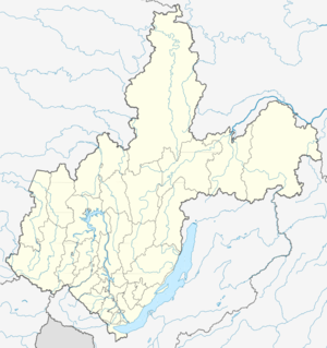 Balagansk | |
|
| |
.png) | |
|
| |
| Administrative status (as of 2011) | |
| Country | Russia |
| Federal subject | Irkutsk Oblast[1] |
| Administrative district | Balagansky District[1] |
| Administrative center of | Balagansky District[1] |
| Municipal status (as of December 2004) | |
| Municipal district | Balagansky Municipal District[2] |
| Urban settlement | Balaganskoye Urban Settlement[2] |
| Administrative center of | Balagansky Municipal District,[2] Balaganskoye Urban Settlement[2] |
| Statistics | |
| Population (2010 Census) | 4,109 inhabitants[3] |
| Time zone | IRKT (UTC+08:00)[4] |
| Established at the old location | 1654[5] |
| Urban-type settlement status since | 1962[5] |
|
| |
| Balagansk on WikiCommons | |
Balagansk (Russian: Балага́нск) is an urban locality (a work settlement) and the administrative center of Balagansky District of Irkutsk Oblast, Russia.[1] It is located on the left bank of the Angara River, downstream from Svirsk and 285 kilometres (177 mi) by road northwest of Irkutsk[6] and to the southeast of Sayansk. Population: 4,109 (2010 Census);[3] 4,307 (2002 Census);[7] 4,136 (1989 Census).[8]
On three sides of Balagansk is the Bratsk Reservoir. The settlement is best known for Balagansk Prison, which was used as one of the Siberian exile camps during the Stalin era.
History
Balagansk was founded in 1654 on the left bank of the Angara River opposite to the mouth of the Unga River by the Cossack detachment lead by Dmitry Firsov in the course of Russian colonization of Siberia. Its name is derived from the word "Bulagat", literally meaning sable hunters, a Buryat tribe.[9] From 1655, mass settlement started in the area; eventually, a colony was built and iron mining developed.[5][10] In 1658, Ivan Pokhabov, the administrator (prikazchik) of Balagansk, caused an outbreak and many Russians were killed by them.[10] Balagansk Fortress (ostrog) was built in Balagansk; the Buryats were attached to it and paid tributes to the Russians.[11] Buryats grew to dominate the area and on April 1, 1818, seventeen clans of the Balagansk Buryats met and adopted a memorandum to submit to the Russian authorities. In their memorandum they raised six issues and also provided action to be taken on each of them which related to courts, private law, criminal law, the rights and duties of the chief Taisha and heads of clans.[12]
In the course of the administrative reform carried out in 1708 by Peter the Great, the area was included in Siberia Governorate. In 1764, Irkutsk Governorate split off, and in 1775, Balagansk became a town and the seat of Balagansky Uyezd of Irkutsk Governorate. In 1924, the uyezds were abolished, the governorate was split into districts, and Balagansk became a part of Ziminsky District. In 1925, it lost town status and was downgraded to a selo. In 1926, Balagansky District was established, and Balagansk became the district center.[5]
In the 19th and the 20th centuries, Balagansk, along with all Siberian towns, was widely used for political exile. Catherine Breshkovsky, known as the Little Grandmother of The Russian Revolution, was sent to Balagansk, a place of her choice on exile, as she expressed that her health would be better protected here.[13][14] Joseph Stalin, when he tried to escape from exile in 1902, visited Balagansk.[9] Balagansk Prison was used as one of the Siberian exile camps for dissidents, persecuted ethnic groups and criminals, and Stalin sent many Jews to the camp.[15] It was one of the oldest buildings in the city but has long been in a dilapidated state.[16]
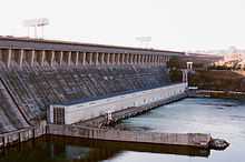
During the construction of Bratsk Hydroelectric Power Station, Balagansk had to be evacuated as it was slated to be submerged under water. A new settlement, Novobalagansk (literally, New Balagansk), was founded in 1957 several dozens kilometers north of the original location of Balagansk to house the residents. The name passed to the new settlement, when it was renamed Balagansk and granted urban-type settlement status on June 5, 1962.[17] In the same year, Balagansky District was abolished,[9] and the settlement was transferred to Zalarinsky District, in 1965 to Ust-Udinsky District, and in 1989 Balagansky District was established, and Balagansk became the administrative center of the district.[5]
Geography
Balagansk is situated on the left bank of the Angara River at the average elevation of 427 metres (1,401 ft). A grotto is located near Balagansk. It is a natural cave or opening whose entrance is formed in a rock face that is 70 feet (21 m) in height with a width of about 180 feet (55 m). When viewed from a distance, it appears to be ruins. In the large opening there are three caverns which lead into three large galleries, each of which is about 1,050 feet (320 m) in length. These join at the end to form a larger cavern which extends further for some distance and terminates at a dead end of a huge mass of ice.[18]
Climate and vegetation
During the Pleistocene period, the climate changes that occurred were severe, which caused changes in distribution patterns of flora and fauna. These changes which occurred between glacial and interglacial periods have been explained under the refugia theory propounded in 1969 by Jürgen Haffer. Balagansk, which is part of the eastern forest-steppes of Tulun-Irkutsk- Balagansk, is reported to possess a different type of Arboreal vegetation. These are mainly pine and larch. The area which is forested constitutes a much greater area than cultivated lands.[19]
The climate of Balagansk is Siberian and the average temperature and rainfall for each month of the year, as given in the table below, are as reported by the Worldweatheronline.[20]
| Climate data for Balagansk, Russia | |||||||||||||
|---|---|---|---|---|---|---|---|---|---|---|---|---|---|
| Month | Jan | Feb | Mar | Apr | May | Jun | Jul | Aug | Sep | Oct | Nov | Dec | Year |
| Average high °C (°F) | −18 (0) |
−14 (7) |
−2 (28) |
7 (45) |
16 (61) |
22 (72) |
25 (77) |
22 (72) |
14 (57) |
4 (39) |
−1.5 (29.3) |
−2.5 (27.5) |
25 (77) |
| Average low °C (°F) | −27 (−17) |
−25 (−13) |
−12 (10) |
−6 (21) |
1 (34) |
9 (48) |
13 (55) |
10 (50) |
3 (37) |
−6 (21) |
−6 (21) |
−16 (3) |
−27 (−17) |
| Average rainfall mm (inches) | 14.5 (0.571) |
7.4 (0.291) |
11.5 (0.453) |
17.1 (0.673) |
32 (1.26) |
65.4 (2.575) |
60.1 (2.366) |
62.5 (2.461) |
43.9 (1.728) |
17.6 (0.693) |
13.5 (0.531) |
17.4 (0.685) |
362.9 (14.287) |
| Source: [20] | |||||||||||||
Economy
Industry
The economy of Balagansk is based on timber and food industries.[21] 2 kilometres (1.2 mi) south of Balagansk, there is a quarry which supplies clay for brick production.[9]
Transportation
The settlement is connected by road with Zalari, where it has access to the M53 highway, connecting Novosibirsk with Irkutsk. The closest accessible railway station is also in Zalari, which lies on the Trans-Siberian Railway. The Angara is navigable.
Culture
The tomb of Władysław Anielewski, a Polish social-democrat who died in 1898, at the old cemetery in Balagansk is protected as a cultural monument of federal significance.[22]
References
Notes
- ↑ 1.0 1.1 1.2 1.3 1.4 1.5 Law #49-OZ
- ↑ 2.0 2.1 2.2 2.3 Law #64-oz
- ↑ 3.0 3.1 Russian Federal State Statistics Service (2011). "Всероссийская перепись населения 2010 года. Том 1" [2010 All-Russian Population Census, vol. 1]. Всероссийская перепись населения 2010 года (2010 All-Russia Population Census) (in Russian). Federal State Statistics Service. Retrieved June 29, 2012.
- ↑ Правительство Российской Федерации. Федеральный закон №107-ФЗ от 3 июня 2011 г. «Об исчислении времени», в ред. Федерального закона №248-ФЗ от 21 июля 2014 г. «О внесении изменений в Федеральный закон "Об исчислении времени"». Вступил в силу по истечении шестидесяти дней после дня официального опубликования (6 августа 2011 г.). Опубликован: "Российская газета", №120, 6 июня 2011 г. (Government of the Russian Federation. Federal Law #107-FZ of June 31, 2011 On Calculating Time, as amended by the Federal Law #248-FZ of July 21, 2014 On Amending Federal Law "On Calculating Time". Effective as of after sixty days following the day of the official publication.).
- ↑ 5.0 5.1 5.2 5.3 5.4 Историческая справка о Балаганском городском поселении с 1654—2007 гг. (in Russian). Администрация посёлка Балаганск. Retrieved 29 January 2013.
- ↑ Geochemistry International. Scripta Publishing Company. 2005. p. 160. Retrieved 29 January 2013.
- ↑ Russian Federal State Statistics Service (May 21, 2004). "Численность населения России, субъектов Российской Федерации в составе федеральных округов, районов, городских поселений, сельских населённых пунктов – районных центров и сельских населённых пунктов с населением 3 тысячи и более человек" [Population of Russia, Its Federal Districts, Federal Subjects, Districts, Urban Localities, Rural Localities—Administrative Centers, and Rural Localities with Population of Over 3,000] (XLS). Всероссийская перепись населения 2002 года [All-Russia Population Census of 2002] (in Russian). Retrieved August 9, 2014.
- ↑ Demoscope Weekly (1989). "Всесоюзная перепись населения 1989 г. Численность наличного населения союзных и автономных республик, автономных областей и округов, краёв, областей, районов, городских поселений и сёл-райцентров" [All Union Population Census of 1989: Present Population of Union and Autonomous Republics, Autonomous Oblasts and Okrugs, Krais, Oblasts, Districts, Urban Settlements, and Villages Serving as District Administrative Centers]. Всесоюзная перепись населения 1989 года[All-Union Population Census of 1989] (in Russian). Институт демографии Национального исследовательского университета: Высшая школа экономики [Institute of Demography at the National Research University: Higher School of Economics]. Retrieved August 9, 2014.
- ↑ 9.0 9.1 9.2 9.3 Балаганский район: земля с сибирским характером. Komsomolskaya Pravda (in Russian). October 2, 2012.
- ↑ 10.0 10.1 Howorth, Henry Hoyle (1 January 2013). History of the Mongols: The Mongols proper and the Kalmuks. With 2 maps by E. G. Ravenstein. Cosimo, Inc. p. 689. ISBN 978-1-60520-133-7. Retrieved 29 January 2013.
- ↑ Michael, Henry N. (1962). Studies in Siberian ethnogenesis. Published for the Arctic Institute of North America by University of Toronto Press. p. 81. Retrieved 29 January 2013.
- ↑ Sinor, Denis (1969). Inner Asia. Psychology Press. p. 58. ISBN 978-0-7007-0380-7. Retrieved 29 January 2013.
- ↑ The Survey: Social, Charitable, Civic : a Journal of Constructive Philanthropy. Charity Organization Society of the City of New York. 1915. Retrieved 3 January 2013.
- ↑ ALCE STONE BLACKWELL (1918). The Little Grandmother Of The Russian Revolution Reminiscences And Letters Of Catherine Breshkovsky. Retrieved 3 January 2013.
- ↑ Montefiore, Simon Sebag (27 May 2010). Young Stalin. Orion. p. 105. ISBN 978-0-297-86384-7. Retrieved 29 January 2013.
- ↑ Kennan, George (26 April 2012). Siberia and the Exile System. Cambridge University Press. p. 526. ISBN 978-1-108-04823-1. Retrieved 29 January 2013.
- ↑ Мельхеев, М.Н. Географические названия Восточной Сибири (in Russian). Природа Байкала. Retrieved 2 February 2013.
- ↑ Reuben Percy; John Timbs (1825). The Mirror of Literature, Amusement, and Instruction. J. Limbird. pp. 351–. Retrieved 3 January 2013.
- ↑ Konstantin Pavlovich Gorshenin (1961). The soils of southern Siberia: from the Urals to the Baikal. Israel Program for Scientific Translations. Retrieved 3 January 2013.
- ↑ 20.0 20.1 "Balagansk Weather". Worldweatheronline.com. Retrieved 31 January 2013.
- ↑ Балаганск (in Russian). Сибирский летописец. Retrieved 29 January 2013.
- ↑ Могила В. Анелевского - участника революционного движения в Польше, делегата на 1 конрессе Второго Интернационала от рабочих России (in Russian). Минкультуры России. Retrieved 29 January 2013.
Sources
- Законодательное Собрание Иркутской области. Закон №49-ОЗ от 21 июня 2010 г. «Об административно-территориальном устройстве Иркутской области», в ред. Закона №183-ОЗ от 31 декабря 2014 г. «Об отдельных вопросах административно-территориального устройства Иркутской области и о внесении изменений в Закон Иркутской области "Об административно-территориальном устройстве Иркутской области"». Вступил в силу после дня официального опубликования. Опубликован: "Областная", №71, 25 июня 2010 г. (Legislative Assembly of Irkutsk Oblast. Law #49-OZ of June 21, 2010 On the Administrative-Territorial Structure of Irkutsk Oblast, as amended by the Law #183-OZ of December 31, 2014 On Various Issues Regarding the Administrative-Territorial Structure of Irkutsk Oblast and on Amending the Law of Irkutsk Oblast "On the Administrative-Territorial Structure of Irkutsk Oblast". Effective as of after the day of the official publication.).
- Законодательное Собрание Иркутской области. Закон №64-оз от 2 декабря 2004 г. «О статусе и границах муниципальных образований Балаганского района Иркутской области». Вступил в силу с 31 декабря 2004 г., но не ранее чем через 10 дней со дня официального опубликования. Опубликован: "Восточно-Сибирская правда", №248–249, 14 декабря 2004 г. (Legislative Assembly of Irkutsk Oblast. Law #64-oz of December 2, 2004 On the Status and Borders of the Municipal Formations of Balagansky District of Irkutsk Oblast. Effective as of December 31, 2004, but not earlier than 10 days after the official publication date.).