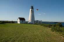
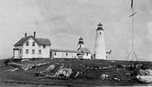
Bakers Island Light
 | |
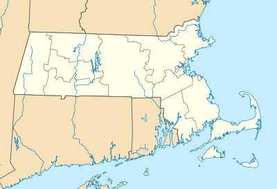 | |
| Location | E of Salem on Bakers Island, Salem, Massachusetts |
|---|---|
| Coordinates | 42°32′11.2″N 70°47′9.3″W / 42.536444°N 70.785917°WCoordinates: 42°32′11.2″N 70°47′9.3″W / 42.536444°N 70.785917°W |
| Year first constructed | 1791 |
| Year first lit | 1821 (current tower) |
| Automated | 1972 |
| Foundation | Granite |
| Construction | Granite and concrete |
| Tower shape | Conical |
| Markings / pattern | White with black lantern |
| Height | 59 feet (18 m) |
| Focal height | 111 feet (34 m) |
| Original lens | 4th order Fresnel lens |
| Current lens | 7.5 inches (190 mm) |
| Range |
White 16 nautical miles (30 km; 18 mi) Red 14 nautical miles (26 km; 16 mi) |
| Characteristic | Alternating White and Red 20s |
| Fog signal | Horn: 1 every 30s |
| Admiralty number | J0288 |
| ARLHS number | USA-031 |
| USCG number | |
|
Baker's Island Light Station | |
| Area | 11.5 acres (4.7 ha) |
| Built | 1821 |
| Governing body | U.S. Coast Guard |
| MPS | Lighthouses of Massachusetts TR (AD) |
| NRHP Reference # | 76000289[4] |
| Added to NRHP | November 21, 1976 |
Bakers Island Light is a historic lighthouse on Bakers Island in Salem, Massachusetts. The station was originally established in 1791, with a daymark. This was replaced in 1798 by two lights atop a keeper's house, one at each end. After storm damage in 1815, an octagonal stone tower was constructed. The current round stone tower was added in 1820. The 1820 tower was taller, leading to the names "Ma" and "Pa". The two remained in service until 1926, when the older, shorter tower was removed.[1]
The light was added to the National Register of Historic Places as Baker's Island Light Station in 1976.
Nomenclature
The City of Salem, the Coast Guard, and NOAA spell the name without an apostrophe, but the National Register of Historic Places includes it. The name is always written with the "s".[5]
See also
- National Register of Historic Places listings in Salem, Massachusetts
- List of lighthouses in the United States, Massachusetts
References
- ↑ 1.0 1.1 "Historic Light Station Information and Photography: Massachusetts". United States Coast Guard Historian's Office.
- ↑ Light List, Volume I, Atlantic Coast, St. Croix River, Maine to Shrewsbury River, New Jersey (PDF). Light List. United States Coast Guard. 2009. p. 5.
- ↑ Rowlett, Russ (2009-12-14). "Lighthouses of the United States: Northern Massachusetts". The Lighthouse Directory. University of North Carolina at Chapel Hill.
- ↑ "National Register Information System". National Register of Historic Places. National Park Service. 2009-03-13.
- ↑ "National Register Historic Districts & Landmarks". City of Salem.
| ||||||||||||||||||||||||||