Bagua Plateau
Coordinates: 23°55′58.0″N 120°37′36.7″E / 23.932778°N 120.626861°E
Bagua Plateau
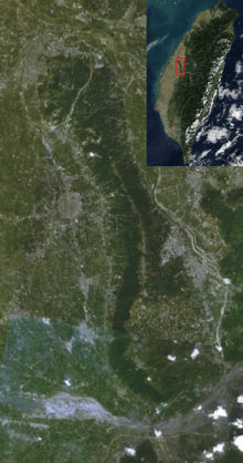
Pakua Plateau or Bagua Plateau (Chinese: 八卦台地; pinyin: Bāguà Táidì), also known as the Pakua Mountain Range (八卦山脈), is located at the central-western Taiwan. It is stretching across the Changhua County and Nantou County. The plateau faces the Changhua Plain on the west and Taichung Basin on the east. It is long and narrow, has a length of about 32 km, and a width of about 4 to 7 km. The highest peak of the plateau is the Mt. Hengshan (橫山), which has a height of 442.6 m.[1] [2] [3] [4]
See also
References
- ↑ "Welcome to Taiwan Tri-Mountain National Scenic Area - ...". eng.taiwan.net.tw. Retrieved 11 March 2014.
- ↑ "Taiwan (China) North Section of Bagua". birdlife.org. Retrieved 11 March 2014.
- ↑ "Yongxing Village". taiseen.org.tw. Retrieved 11 March 2014.
- ↑ "Plateaus in Asia". physicalmapofasia.com. Retrieved 11 March 2014.
| ||||||||||||||||||||||||||