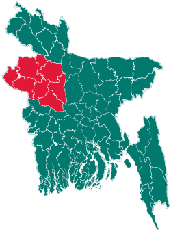
Bagatipara Upazila
| Bagatipara বাগাতিপাড়া | |
|---|---|
| Upazila | |
 Bagatipara Location in Bangladesh | |
| Coordinates: 24°19.8′N 88°56.7′E / 24.3300°N 88.9450°ECoordinates: 24°19.8′N 88°56.7′E / 24.3300°N 88.9450°E | |
| Country |
|
| Division | Rajshahi Division |
| District | Natore District |
| Area | |
| • Total | 139.37 km2 (53.81 sq mi) |
| Population (1991) | |
| • Total | 107,944 |
| • Density | 775/km2 (2,010/sq mi) |
| Time zone | BST (UTC+6) |
| Website | Official Map of Bagatipara |
Bagatipara (Bengali: বাগাতিপাড়া) is an Upazila of Natore District in the Division of Rajshahi, Bangladesh.
Geography
Bagatipara is located at 24°19′50″N 88°56′40″E / 24.3306°N 88.9444°E. It has an area of 139.37 km2 and is bounded by Natore Sadar Upazila on the north, Lalpur Upazila on the south, Baraigram Upazila on the east and Charghat, Bagha and Puthia Upazilas on the west. The soil of the upazila is mainly plain; there are few depressions. The main river is Baral.
Demographics
As of the 1991 Bangladesh census, Bagatipara has a population of 107944. Males constitute 51.49% of the population, and females 48.51%. The Upazila's adult population is 54158. Bagatipara has an average literacy rate of 31.2% (7+ years), and the national average of 32.4% literate.[1]
See also
References
- ↑ "Population Census Wing, BBS.". Archived from the original on 2005-03-27. Retrieved November 10, 2006.
| |||||||||||||||||||||||||||||||||||||||||
