Bad Oeynhausen
| Bad Oeynhausen | ||
|---|---|---|
 | ||
| ||
 Bad Oeynhausen | ||
Location of Bad Oeynhausen within Minden-Lübbecke district 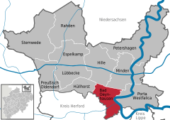
 | ||
| Coordinates: 52°12′N 08°48′E / 52.200°N 8.800°ECoordinates: 52°12′N 08°48′E / 52.200°N 8.800°E | ||
| Country | Germany | |
| State | North Rhine-Westphalia | |
| Admin. region | Detmold | |
| District | Minden-Lübbecke | |
| Government | ||
| • Mayor | Klaus Mueller-Zahlmann (SPD) | |
| • Governing parties | SPD | |
| Area | ||
| • Total | 64.8 km2 (25.0 sq mi) | |
| Population (2013-12-31)[1] | ||
| • Total | 48,294 | |
| • Density | 750/km2 (1,900/sq mi) | |
| Time zone | CET/CEST (UTC+1/+2) | |
| Postal codes |
32545, 32547, 32549 | |
| Dialling codes |
05731, 05734 | |
| Vehicle registration | MI | |
| Website | www.badoeynhausen.de | |

Bad Oeynhausen (German pronunciation: [ˈbaːt ˈøːnhaʊzən]) (Low German: Bad Öinusen) is a spa town in the Minden-Lübbecke district, in North Rhine-Westphalia, Germany. The closest larger towns are Bielefeld (39 kilometres southwest) and Hanover (80 km east)
Geography
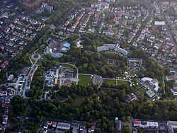
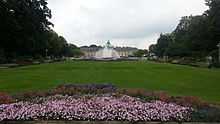
Bad Oeynhausen is located on the banks of the Weser river, which runs along the eastern edges of the town. Bad Oeynhausen has the world's highest carbonated, thermal saltwater fountain, the Jordan Sprudel (or the Jordansprudel). On calm days the fountain gets up to 40 metres high. The water of the spring is believed to have many medicinal qualities, giving rise to a number of health spas.
Land use
The soil is very fertile, so a lot of the area is used for agriculture:
| Area |
Settlement and circulation area |
Farmland |
Forest |
Other free area |
|---|---|---|---|---|
| Area in hectares | 2,479 | 3,348 | 518 | 135 |
| Complete percentage | 38.3% | 51.7% | 8.0% | 2.0% |
This applies to the entire district of Minden-Lübbecke. The majority of the land is used for agriculture.
| Area usage of Minden-Lübbecke [2] |
All told | Farmland |
Forests |
Settlement and circulation area |
Water area |
Other land usage |
|---|---|---|---|---|---|---|
| Area in km² | 1152.22 | 756.7 | 128.98 | 220.13 | 34.08 | 12.33 |
| Complete percentage | 100% | 65.7% | 11.2 % | 19.1% | 3% | 1% |
Neighbouring places
Division of the town
Bad Oeynhausen consists of 8 districts:
|
|
International relations
Twin towns — Sister cities
Bad Oeynhausen is twinned with:
-
 Fismes (Champagne-Ardenne, France) (originally a twin town to Eidinghausen)
 -
 Wear Valley (United Kingdom)
 -
 Inowrocław (Poland)
Climate
The climate in Bad Oeynhausen is controlled by the Oceanic Climate. The values are based on the ones from Herford (Temperature)[3] and the ones in Bad Oeynhausen (Precipitation) [4]
| Monat | Jan | Feb | Mar | Apr | May | Jun | Jul | Aug | Sep | Okt | Nov | Dez | Year | |
| Temperature in °C | 1.3 | 1.9 | 4.7 | 8.4 | 13.0 | 15.9 | 17.4 | 17.1 | 14.0 | 10.2 | 5.4 | 2.5 | 9.4 | |
| Precipitation in millimetres | 61.3 | 45.7 | 57.7 | 52.2 | 62.4 | 73.9 | 66.1 | 65.5 | 60.9 | 46.7 | 61.5 | 71.1 | 724.8 |
Notable Buildings
Bad Oeynhausen built a mall called the "Werre-Park". It gets its name from the nearby river Werre and was opened on the first of April 1998

History
In the village of Bergkirchen, which belongs to Bad Oeynhausen, a wellspring sanctuary existed in pre-Christian (Saxon) times at the local crossing of the Wiehengebirge, which was replaced in the 9 th century by a church. Today's church is a subsequent building. On the church and the downhill-situated Widukind-spring plates explain this further. A few meters from the church a 13 th century timbered homestead can still be found.
In 753 Pepin the Short, according to the Frankish Chronicles, stopped over ad locum qui dicitur Rimiae, so that Rehme is commonly accepted as the oldest part of town. Another source, describing Nero Claudius Drusus’ Germania campaigns and stating that he once camped ad locum qui dicitur Rimi, and thus would date Rehme's proven existence as far back as 11 BC, but is not officially accepted.
In 1745 a farmer named Sültemeyer was wondering about the salty crust on his pig's backs after wallowing in the mud. After public awareness of this finding King Frederick II of Prussia ordered the construction of a saline, which was named "Royal Saline Neusalzwerk". Today's Sültemeyer-Fountain (colloquial: Pig-Fountain) — located in the city centre — is a reminder of the city's beginning.

From 1830 on the mining captain Carl Baron of Oeynhausen (1795–1865) oversaw the drilling on today's spa garden area in search for salt deposits, but instead found a thermal salt spring in 1845. Quickly the healing abilities of this spring were discovered and first baths were built in the community, which now was called "Neusalzwerk near Rehme". In 1848 King Frederick William IV of Prussia renamed it to "Royal Bath (German: Bad) Oeynhausen", which was kept as the name after receiving its own town charter town in 1860. The opening of the Cologne-Minden railway line in 1849 connected the city with railroad network.
The following growth of spa activities and the urban development continued into World War II. Among other things the Kurpark (spa garden), according to lay-out plans by Peter Joseph Lenné, and the Kurhaus (spa hotel) in 1908 (from 1980-2002 a Casino was located here; today called Kaiserpalais it hosts a Varieté, a noble restaurant and a discothèque) were constructed. At the beginning of the 20 th century residential houses for the bourgeoisie were built around the spa garden.
The extraordinary conglomeration of different architectural styles of the spa garden's buildings and the surrounding mansons bestowed Bad Oeynhausen the unofficial title "Museum for the Architecture of the 19th Century". One of the most famous buildings, the "Farne-Villa" was replaced by a new building in 1969.
In the first half of the 20 th century additional thermal salt springs were drilled. Among these the Jordansprudel, drilled in 1926, is best known and with a capacity of 6000 l/min and a total height of up to 40 m it is the world's highest carbonated thermal salt spring and de facto the town's landmark.
Under Nazi Germany, Bad Oeynhausen hosted a synod of the Confessing Church, as well as the home congregation to Jakob Emil Karl Koch, a leading member. The World War II tank factory of the town was bombed on March 30, 1945. Post-war, the town hosted the Control Commission for Germany - British Element (CCG/BE), the military government for the British Zone of Occupation and served as the British Army of the Rhine headquarters.
The town was returned to local control in 1954 and spa activities resumed. In 1976, seven surrounding municipalities of the "Amt Rehme" merged with Bad Oeynhausen into one commune. As the last state owned spa (German: Staatsbad) of NRW, in early 2004 Bad Oeynhausen was municipalised.
Population Development
|
|
|
¹ census result
Health treatment facilities
There are a number of health treatment facilities in Bad Oeynhausen. The Maternus Rehabilitation Clinic deals with rehabilitation for orthopedic, degenerative, and neurological conditions. The Klinik am Korso deals with eating disorders. The Median Rehabilitation Clinic specializes on rehabilitation for Muslim patients. The Heart and Diabetes Center North Rhine-Westphalia, an institution of the Ruhr University Hospitals, is a world-leading institution for the treatment of cardiac, circulatory and metabolic diseases. Just outside of the city lies the Klinik Bad Oexen, a rehabilitation center for cancer patients.
Notable persons
The German international and VfL Wolfsburg footballer Arne Friedrich was born here, in addition to André Borchers.[5]
References
- ↑ "Amtliche Bevölkerungszahlen". Landesbetrieb Information und Technik NRW (in German). 4 September 2014.
- ↑ Landesamt für Datenverarbeitung und Statistik Nordrhein-Westfalen: Kommunalprofil Kreis Mindne-Lübbecke (PDF; 219 kB)
- ↑ Temperaturdaten des DWD 1961–1990
- ↑ Niederschlagsdaten des DWD 1961–1990 (zip; 349 kB)
- ↑ http://www.nw.de/lokal/kreis_minden_luebbecke/bad_oeynhausen/bad_oeynhausen/9505179_Frueher_dachte_ich_designen_waere_einfach.html?set_style=0
External links
| Wikimedia Commons has media related to Bad Oeynhausen. |
- Official website (German)
-
 "Oeynhausen". Encyclopædia Britannica (11th ed.). 1911.
| ||||||||