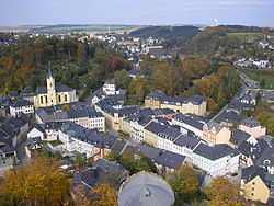
Bad Lobenstein
| Bad Lobenstein | ||
|---|---|---|
 | ||
| ||
 Bad Lobenstein | ||
Location of Bad Lobenstein within Saale-Orla-Kreis district 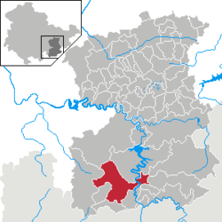 | ||
| Coordinates: 50°27′0″N 11°39′0″E / 50.45000°N 11.65000°ECoordinates: 50°27′0″N 11°39′0″E / 50.45000°N 11.65000°E | ||
| Country | Germany | |
| State | Thuringia | |
| District | Saale-Orla-Kreis | |
| Government | ||
| • Mayor | Peter Oppel (SPD) | |
| Area | ||
| • Total | 48.94 km2 (18.90 sq mi) | |
| Population (2013-12-31)[1] | ||
| • Total | 6,108 | |
| • Density | 120/km2 (320/sq mi) | |
| Time zone | CET/CEST (UTC+1/+2) | |
| Postal codes | 07351–07356 | |
| Dialling codes | 036651 | |
| Vehicle registration | SOK | |
| Website | www.moorbad-lobenstein.de | |

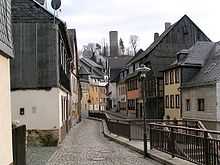
Bad Lobenstein is a town in the Saale-Orla-Kreis district, in Thuringia, Germany with a population of circa 7,000 inhabitants. The town, grouped round a rock, upon which stand the ruins of an old castle, is exceedingly picturesque. It contains a spacious parish church, a palace (until 1824 the residence of the princes of Reuss-Lobenstein-Ebersdorf), and a hydropathic establishment. The manufactures include dyeing, brewing and cigar-making.[2]
History
Within the German Empire (1871-1918), Lobenstein was part of the Principality of Reuss-Gera.
| Wikimedia Commons has media related to Bad Lobenstein. |
References
- ↑ "Bevölkerung der Gemeinden, erfüllenden Gemeinden und Verwaltungsgemeinschaften nach Geschlecht in Thüringen". Thüringer Landesamt für Statistik (in German). 13 July 2013.
- ↑
 One or more of the preceding sentences incorporates text from a publication now in the public domain: Chisholm, Hugh, ed. (1911). Encyclopædia Britannica 16 (11th ed.). Cambridge University Press. p. 837.