Bad Godesberg
| Bad Godesberg | ||
|---|---|---|
| Stadtbezirk of Bonn | ||
|
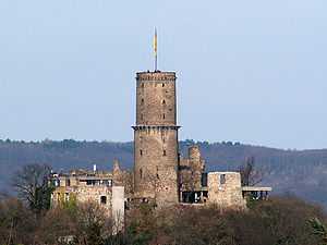
Godesburg ruins | ||
| ||
 Bad Godesberg | ||
Bad Godesberg within Bonn  | ||
| Coordinates: 50°41′0″N 07°9′0″E / 50.68333°N 7.15000°ECoordinates: 50°41′0″N 07°9′0″E / 50.68333°N 7.15000°E | ||
| Country | Germany | |
| State | North Rhine-Westphalia | |
| Admin. region | Cologne | |
| District | Bonn urban district | |
| Town | Bonn | |
| Government | ||
| • Bezirksvorsteherin | Annette Schwolen-Flümann (CDU) | |
| Area | ||
| • Total | 31.97 km2 (12.34 sq mi) | |
| Population (2004-01-01) | ||
| • Total | 70,525 | |
| • Density | 2,200/km2 (5,700/sq mi) | |
| Time zone | CET/CEST (UTC+1/+2) | |
| Postal codes | 53173-53179 | |
| Dialling codes | 0228 | |
| Vehicle registration | BN | |
| Website | Official Website | |
Bad Godesberg is a municipal district of Bonn, southern North Rhine-Westphalia, Germany. From 1949 till 1999 (while Bonn was the capital of West Germany), the majority of foreign embassies to Germany were located in Bad Godesberg. Some buildings are still used as embassy branch offices or consulates.
Geography

Bad Godesberg is located along the hills and cliffs of the west bank of the Rhine river, in west central Germany. Godesberg is also the name of the steep hill, of volcanic origin, on the top of which are the ruins of the Godesburg, a castle destroyed in 1583 during the Cologne War.
History
The following events occurred, per year:
- 722 - First official record of the town, which was named after a nearby mountain, the Woudenesberg (later Godesberg), a basalt cone where the Ubii, a Germanic tribe, worshipped the god Wotan.[1]
- 1210 - On 15 October, Archbishop of Cologne Dietrich I lays the foundation stone of the Godesburg fortress on the Godesberg mountain.
- 1583 - On 17 December, the Godesburg is destroyed by Bavarian troops after Archbishop Gebhard Truchsess von Waldburg converted to Protestantism (see Cologne War).
- 1792 - Godesberg becomes a spa resort.
- 1925 - Godesberg is allowed to call itself "Bad" Godesberg, identifying it as a spa.
- 1935 - Bad Godesberg attains the status of a town.
- 1938 - Neville Chamberlain meets with Hitler over the Sudetenland crisis at the Rheinhotel Dreesen in Bad Godesberg.
- 1945 - Bad Godesberg was the first major German city to be transferred to Allied forces control without a battle.
- 1959 - The Social Democratic Party of Germany (SPD) decided on a new party program, the Godesberg Program.
- 1969 - Godesberg was incorporated into the city of Bonn. Since that time, it has been referred to as the "posh part of Bonn".
Infrastructure
Bonn-Bad Godesberg station is on the Left Rhine line and the line 16 and 63 of the Bonn Stadtbahn.
Twin towns
The town is twinned with several towns:
 Saint-Cloud in France (since 1957)
 Frascati in Italy (since 1960)
 Windsor and Maidenhead in the United Kingdom (since 1960)
.svg.png) Kortrijk in Belgium (since 1964).
Kortrijk in Belgium (since 1964). Yalova in Turkey (since 1989)
Education
Secondary schools
- Nicolaus-Cusanus-Gymnasium (NCG)
- Aloisiuskolleg (AKO), partnerschool of the CFG
- Amos-Comenius-Gymnasium Bonn (AMOS/ACG)
- Clara-Fey-Gymnasium (CFG), partnerschool of the AKO
- Konrad-Adenauer-Gymnasium (KAG)
- Pädagogium Godesberg - Otto-Kühne-Schule (PÄDA)
International schools
Trivia
- John le Carré's novel The Little Drummer Girl begins with the bombing of the house of the Israeli labor attaché in Bad Godesberg.
References
| Wikimedia Commons has media related to Bad Godesberg. |
External links
- Official website (German)
- Bad Godesberg section of Bonn city website (English)
- Information for a popular stop/start along the KD Rhine Cruise (English)
| ||||||||||