Back of the Wight
Back of the Wight is an area on the Isle of Wight, England that has a unique history and social background. Part of this stems from the fact that the area was and still is very cut off from the rest of the Island and is made up of small villages strung out along the coast, such as Brighstone, Shorwell and Mottistone.
Geography
Roughly speaking the Back of the Wight is the land on the southern side of the downs in the West and the boundary following the curve of the downs till they meet the sea near St. Catherine's Point. The main part of the Back of the Wight[1] is formed of a large bay 18 miles long. The shore is edged by cliffs averaging around 300 feet high from Freshwater to Compton, broken at two points, Grange Chine and Brook Chine, which provide the only easy, natural access to the sea through steep gorges. Stretching out from this coast are three ledges of resistant rock, the Brook, Brighstone and Atherfield ledges, on which many ships have been wrecked over the years.
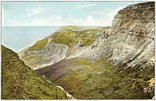
Past Compton and Brighstone, the coast is wild and there are only four access points inland, Whale, Walpen and Ladder Chine and the greatest of them all, Blackgang Chine, which was once a home of smugglers.[2] This shore is in constant threat of erosion.
The most obvious natural features on land are the downs that enclose the area and cut it off from the rest of the island; parts of these are protected as a Site of Special Scientific Interest and large stretches owned by the National Trust. Brighstone Forest, which covers the top of Brighstone Down, is the largest on the island.
At St. Catherine's Point, the Back of the Wight changes into the Undercliff of Ventnor.
Geology
The geology of the area is mainly chalk, a fact proved most dramatically by the cliffs near Freshwater and at Compton, where clay starts to occur as well, these formations are unique for the way the layers have been tilted exposing ancient, fossil bearing strata of the Vectis Formation overlaid with the Wessex Formation.[3]
Settlements
Most of the settlements in the area are villages or hamlets that have evolved around farms or water courses. Settlement in the area has never been great and the villages are mostly old in construction. Many exist because of medieval churches and manors such as Mottistone Manor. The main settlements are:[4][5]
- Brighstone, near the centre
- Brook
- Shorwell
- Mottistone
- Chale
- Freshwater, on the edge of the area
History
Pre-history
There is little evidence of the region having been settled in pre-history; apart from the Longstone[6][7] at Mottistone there are few artefacts. That there were once dinosaurs is proved by the numerous types of bones and fossils that have been excavated from the cliffs, including some species unique to the island. At the time the fossils were laid down, between 125 and 110 million years ago, the island was at a latitude similar to that of North Africa.[8]
Romans
In AD 43 the Romans invaded the island, which they called Vectis. Although most of their presence was elsewhere, they did built a villa at Rock,[9] Brighstone to make use of the clean waters of the Buddle Brook. During the 4th century the Empire broke up and the coast began to suffer from raids by Vikings and Germanic tribes, which repeatedly laid waste to the area.
Saxons
In Saxon times the island was colonised by Jutes until the reign of King Arwald, who died in battle when the kingdom of Wessex invaded and converted the island at sword point by killing the inhabitants and re-settling it with Saxons.[10] Saint Wilfred and the church were given large parts and converted the survivors. The island had been the last pagan part of England.
The Back of the Wight had a meagre and fragile economy at the time so this increased the hardships on the area by killing many of the population.
Middle Ages
During medieval times the people of the Back of the Wight were very poor, particularly compared to the new prosperity of towns such as Yarmouth, Newtown and Brading. The people lived a harsh existence exposed to the elements and pirates. They scraped a livelihood from fishing, farming and salvage. Shipwrecks were a great help to these people and some say that the emphasis was on cargo not people. There has never been any proof of islanders wrecking, but given how harsh their lives were it would not be surprising. In 1313, in a famous case the St Mary of Bayonne, from Gascony, ran ashore at Chale Bay. The lord of Chale raised some men and demanded the 53 barrels of wine the ship was carrying. When King Edward II found out, he summoned them to Southampton and had them fined. The wine was destined for a monastery and the church cried sacrilege. As a result of this incident, the first lighthouse on Wight was built at Chale, the St Catherine's Oratory,[11] where the lord's family paid for a light and prayers for his soul. This is the oldest medieval lighthouse in England.[12] Its ruins are now known as the Pepperpot, and a half-built later lighthouse nearby is known as the Salt Shaker. From this period onwards the area lived in fear of French invasions.
18th century and beyond
In the 18th century there were a succession of stormy winters that increased the number of wrecks on the Back's coast. Salvage and theft were combined with thriving local smuggling. Many buildings in the area are formed of parts of these ships. The Coastguard were established on the Island at this time. They were hated because they fought the smuggling trade, although they were hardly saints; there is an interesting local tale about the commander of the Yarmouth station who "couldn't hear" the sounds of a raging gun battle going on at Alum Bay between smugglers and Coastguard. In 1859 the first lifeboats were put in place at Brighstone and Brook; they took part in many famous rescues and are commemorated in Brighstone Museum, which has many artefacts of the era.
When in 1892 the SS Eider,[13] a German liner, went aground on the Atherfield Ledge, it took "virtually the whole of the sparse human population of the 'Back of the Wight' to get them to sea".[14]

Also in the late 19th century, the area first became popular to visit and some noted figures established homes here, like Mottistone Manor for the noted architects, the Seelys.[15]
Noted shipwrecks
Several local books include detailed accounts of the lifeboat and coastguard rescues of the sailors of the many ships that have been wrecked on the area's dangerous coast. Some of the more high-profile vessels include:

- Needles
SS Irex, HMS Pomone, HMS Assurance, SS Varvassi.
- The South West
MV Ice Prince, Vénus, SS Eider, the Sirenia and the Cedrine, whose timbers form part of Mottistone church.
Today
Today the region is popular with tourists with attractions such as Blackgang Chine, Isle of Wight Pearl and the picture-postcard villages. The area hosts several events over the year including the Brighstone Christmas Tree Festival, Brighstone Show and Chale Show.
The area is still poorly connected, particularly as erosion threatens the A3055 Military Road[16] ("Millie" to locals), which runs along the coast connecting them. Compton bay and beach are popular with surfers due to waves that come across the Atlantic. Recent cuts have made the bus service more infrequent.
Agriculture is still the dominant ecnomic activity of the land. Many residents of the area have Newport as their centre of commerce and culture, using the road over the down to reach it.[17]
Politics
There is some strain in the area because of the strong East-West rivalry on the island and the fact that there has been little investment recently. The roads vary greatly in condition with many being poor, in contrast to the mainly good quality of Eastern infrastructure. The recent proposals to split the island into two constituencies could result in the West having a separate MP.
Economy
The economy of the area is largely agricultural and rural with farming using most of the land area. Despite the long coastline, there is little or no local fishing. Tourism provides a significant part of local income and many sites in the area are popular.
See also
Notes
- ↑ isleofwight.co.uk/
- ↑ J.C Medland "Shipwrecks of the Wight".Coach House Publications ltd, 2004
- ↑ http://www.dinowight.co.uk/
- ↑ English Parishes & Welsh Communities N&C 2004
- ↑ http://www.iwight.com/just_visiting/towns/brighstone
- ↑ http://www.mysteriousbritain.co.uk/england/isle-of-wight/ancient-sites/the-longstone-at-mottistone
- ↑ http://www.isleofwightattractions.co.uk/TheLongStone
- ↑ DinoWight – The Dinosaurs of the Isle of Wight
- ↑ http://www.roman-britain.org/places/vectis.htm
- ↑ freespace.virgin.net/roger.hewitt/iwias/history.htm
- ↑ BBC h2g2 – The Pepper Pot
- ↑ Tony Denton and Nicholas Leach, Lighthouses of England and Wales: A Complete Guide, Landmark Publishing Ltd, 2008.
- ↑ http://www.backofthewight.co.uk
- ↑ J.C Medland, The Making of the Wight, Volume 2, The Isle of Wight Beacon Ltd 2008.
- ↑ Details from listed building database (392902).
- ↑ Military Road
- ↑ http://www.islandstudies.ca/sites/islandstudies.ca/files/ISJ-6-2-2011-Grydehoj+Hayward.pdf