Back River Light
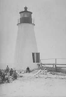 Undated photograph of Back River Light, Virginia (USCG) | |
 | |
| Location | 1 nmi (1.9 km; 1.2 mi) south of the mouth of the Back River on the western shore of the Chesapeake Bay |
|---|---|
| Coordinates | 37°05′14″N 76°16′11″W / 37.0872°N 76.2698°WCoordinates: 37°05′14″N 76°16′11″W / 37.0872°N 76.2698°W |
| Year first lit | 1829 |
| Automated | 1915 |
| Deactivated | 1936 |
| Construction | brick/masonry |
| Tower shape | conical tower |
| Height | 30 feet (9.1 m) |
The Back River Light also known as the Grandview Light was a lighthouse south of the mouth of the Back River on the western shore of the Chesapeake Bay, several miles north of Fort Monroe near Hampton, Virginia. Plagued by erosion for most of its existence, it was destroyed in 1956 by Hurricane Flossy.
History
This lighthouse constructed in 1829, was a 30-foot (9.1 m) conical masonry tower similar to others further up the bay. A hint of its coming travails was given by the need for a 144-foot (44 m) long footbridge to carry the keeper over the marshy land between the tower and his house.
The light was damaged by Confederate raiders in 1862, but was back in service the following year. But the remainder of the century saw a continuing battle against erosion, and riprap was laid around the base of the tower several times between 1868 and 1888. In 1894 a second story was added to the keeper's house, but this served only until 1914, when the house facing destruction due to beach erosion was demolished, with the light being automated the following year. The light was discontinued in 1936. Twenty years later the abandoned tower, by then completely surrounded by water due to erosion, collapsed during Hurricane Flossy, leaving only a pile of rubble to mark the spot.
Notes
References
- de Gast, Robert (1973). The Lighthouses of the Chesapeake. Baltimore: Johns Hopkins University Press.
- "Historic Light Station Information and Photography: Virginia". United States Coast Guard Historian's Office.