Béthune (river)
| Béthune | |
|---|---|
 | |
| Origin | Gaillefontaine |
| Mouth |
Arques River 49°53′29″N 1°7′51″E / 49.89139°N 1.13083°ECoordinates: 49°53′29″N 1°7′51″E / 49.89139°N 1.13083°E |
| Basin countries | France |
| Length | 61 km |
| Source elevation | 160 m |
| Avg. discharge | 2.9 |
| Basin area | 307 km² |
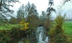
The Béthune is a river of Normandy, France, 61 kilometres (38 mi) in length, flowing through the department of Seine-Maritime and it is a tributary of the Arques River. The French Sandre regulators however, consider the Béthune as the Arques for all its length.[1]
Geography

The river’s source is at the village of Gaillefontaine near to Forges-les-Eaux. Its valley is wholly within the pays de Bray. Its course takes it past the communes of Neufchâtel-en-Bray, Mesnières-en-Bray, Bures-en-Bray, Osmoy-Saint-Valery, Saint-Vaast-d'Équiqueville, Dampierre-Saint-Nicolas, Saint-Aubin-le-Cauf and finally Arques-la-Bataille where it joins the Eaulne and the Varenne Rivers to form the Arques River
Like other rivers in the region, the Béthune is classified as a first class river, offering anglers the chance to catch salmon and trout.
See also
Notes
- ↑ The Béthune on the Sandre website. Consulted 8 June 2008.
- This article is based on the equivalent article from the French Wikipedia, consulted on October 14, 2008.
External links
- The Béthune on the Sandre website (French)
- Accès aux villes et villages de France du Quid (French)
- French Geography website (French)