Azay-sur-Indre
| Azay-sur-Indre | ||
|---|---|---|
|
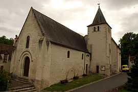
The church in Azay-sur-Indre | ||
| ||
 Azay-sur-Indre | ||
|
Location within Centre region  Azay-sur-Indre | ||
| Coordinates: 47°12′35″N 0°56′46″E / 47.2097°N 0.9461°ECoordinates: 47°12′35″N 0°56′46″E / 47.2097°N 0.9461°E | ||
| Country | France | |
| Region | Centre-Val de Loire | |
| Department | Indre-et-Loire | |
| Arrondissement | Loches | |
| Canton | Loches | |
| Government | ||
| • Mayor (2008–2014) | Jean-Jacques Meunier | |
| Area1 | 13.89 km2 (5.36 sq mi) | |
| Population (2009)2 | 381 | |
| • Density | 27/km2 (71/sq mi) | |
| INSEE/Postal code | 37016 / 37310 | |
| Elevation | 61–106 m (200–348 ft) | |
|
1 French Land Register data, which excludes lakes, ponds, glaciers > 1 km² (0.386 sq mi or 247 acres) and river estuaries. 2 Population without double counting: residents of multiple communes (e.g., students and military personnel) only counted once. | ||
.svg.png)
Azay-sur-Indre is a commune in the Indre-et-Loire department in central France.
Geography
The Indrois flows west through the eastern part of the commune, then flows into the Indre.
The village lies in the middle of the commune, on the left bank of the Indre, which flows northwest through the middle of the commune.
Population
| Historical population | ||
|---|---|---|
| Year | Pop. | ±% |
| 1793 | 359 | — |
| 1800 | 459 | +27.9% |
| 1806 | 414 | −9.8% |
| 1821 | 409 | −1.2% |
| 1831 | 427 | +4.4% |
| 1836 | 452 | +5.9% |
| 1841 | 461 | +2.0% |
| 1846 | 455 | −1.3% |
| 1851 | 464 | +2.0% |
| 1856 | 461 | −0.6% |
| 1861 | 487 | +5.6% |
| 1866 | 492 | +1.0% |
| 1872 | 477 | −3.0% |
| 1876 | 503 | +5.5% |
| 1881 | 421 | −16.3% |
| 1886 | 413 | −1.9% |
| 1891 | 409 | −1.0% |
| 1896 | 384 | −6.1% |
| 1901 | 398 | +3.6% |
| 1906 | 381 | −4.3% |
| 1911 | 366 | −3.9% |
| 1921 | 322 | −12.0% |
| 1926 | 323 | +0.3% |
| 1931 | 20 | −93.8% |
| 1936 | 321 | +1505.0% |
| 1946 | 337 | +5.0% |
| 1954 | 391 | +16.0% |
| 1962 | 341 | −12.8% |
| 1968 | 307 | −10.0% |
| 1975 | 272 | −11.4% |
| 1982 | 289 | +6.2% |
| 1990 | 309 | +6.9% |
| 1999 | 355 | +14.9% |
| 2006 | 370 | +4.2% |
| 2009 | 381 | +3.0% |
See also
References
| Wikimedia Commons has media related to Azay-sur-Indre. |