Ayer (MBTA station)
AYER | |||||||||||
|---|---|---|---|---|---|---|---|---|---|---|---|
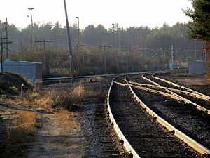
 Platforms at Ayer, looking westward | |||||||||||
| Location |
70 Main Street Ayer, MA 01432 | ||||||||||
| Coordinates | 42°33′32.63″N 71°35′22.82″W / 42.5590639°N 71.5896722°WCoordinates: 42°33′32.63″N 71°35′22.82″W / 42.5590639°N 71.5896722°W | ||||||||||
| Line(s) | |||||||||||
| Platforms | 2 side platforms | ||||||||||
| Tracks | 3 | ||||||||||
| Construction | |||||||||||
| Parking | 30 spaces (free) | ||||||||||
| Other information | |||||||||||
| Fare zone | 8 | ||||||||||
| History | |||||||||||
| Opened | December 1845 | ||||||||||
| Closed |
January 18 - June 28, 1965 March 1, 1975 - January 13, 1980[1] | ||||||||||
| Traffic | |||||||||||
| Passengers (2009) | 490 (weekday inbound average)[2] | ||||||||||
| Services | |||||||||||
| |||||||||||
Ayer is a passenger rail station on the MBTA Commuter Rail Fitchburg Line in the downtown area of Ayer, Massachusetts. The station is located at 70 Main Street in the Ayer Main Street Historic District.[3] There are three tracks through the station, two of which are served by a pair of low-level side platforms, which are not handicapped-accessible. There is a shelter on the inbound platform.
Ayer has been a major railroad interchange since the Fitchburg Railroad opened in 1845. By 1900, the town was served by five railroads, with service to Boston, Worcester, and Lowell plus New York, New Hampshire, and Maine. Although passenger service now runs only on the Fitchburg Line, Pan Am Railways runs freight trains through the town to various destinations. Ayer has seen continuous passenger service since 1845, except for 1975-1980 and a brief period in 1965.
History
Fitchburg Line

The town is located on the Fitchburg Railroad main line, which opened through Ayer in December 1845.[4] When the Hoosac Tunnel opened in 1875, trains through Ayer could run on the Fitchburg and the Vermont and Massachusetts Railroad as far west as Troy, New York.[4] The Fitchburg Railroad was acquired by the Boston and Maine Railroad in 1900. Ayer station, sometimes known as Ayer Junction and Groton Junction, was the most important station on the Fitchburg Railroad between Concord and Fitchburg. By the late 1800s, Ayer station consisted of a large depot that spanned the Fitchburg's tracks.[5]
Service along the line was cut back to Fitchburg in 1960, then to West Concord on January 18, 1965. On June 28, 1965, the newly formed Massachusetts Bay Transportation Authority established funding for restoration of service back to Ayer and intermediate stops.[1] One half of the station building was torn down around 1960; the other lasted till later that decade. The foundation of one building is still present in the wye.
In December 1973, state subsidies for towns outside the MBTA funding district were halved, resulting in the MBTA needing to renegotiate subsidies from 14 municipalities. Ultimately Ayer, with just 14 daily commuters, refused to pay its $8200 bill in 1974; Littleton also did not reach an agreement.[6] On March 1, 1975, the line was cut back to South Acton, dropping stops at Ayer, Littleton, and West Acton.[7][1]
On December 27, 1976, the MBTA bought the Boston and Maine Railroad's northside commuter rail assets, including the entire length of the Fitchburg Line.[1] The closure of the Lexington Branch the next month represented the limit of the contraction of the northside lines; as a results of the 1970s energy crisis and especially the 1979 energy crisis, a period of rapid expansion began in the end of the 1970s. Service to Ayer returned along with an extension to Gardner on January 13, 1980.[1] Ayer has seen continuous MBTA service since 1980, although service beyond Ayer was cut from Gardner to Fitchburg at the end of 1986.
In April 2014, pedestrian access to the station was partially cut off when an abutting landowner erected a fence on the station's primary access point. The landowner was angered by commuters parking in his business lot (Ayer has no dedicated station parking).[8]
Other lines


The northernmost track through the station connects to the former Peterborough and Shirley Railroad. which was built in 1847-50. Passenger service on the line ended in 1933; it is used solely by Pan Am Railways, which runs freight to a paper plant at Vose, near West Groton.[4] The line is also used for storage of freight cars. The Brookline and Pepperell Railroad formerly connected to the Peterborough and Shirley in West Groton and ran trains through Ayer. The line opened in 1894; passenger service ended in September 1931 and the line was abandoned in 1942.[4]
The station itself is located inside a wye that connects to the former southern section of Worcester and Nashua Railroad, now the Pan Am Railways Worcester Branch.[4] The Worcester & Nashua opened between Worcester and Ayer in July 1848 and to Nashua, New Hampshire in December. Passenger service on the line ended north of Ayer in 1934; it was abandoned in 1982 and turned into the Nashua River Rail Trail.[4] Local service between Ayer and Worcester lasted until 1953; the State of Maine used the line until October 29, 1960, and the Boston and Maine Railroad ran a single Budd RDC car between Worcester and Haverhill until 1961 by state order.[4] The line is now used regularly by Pan Am, which directs most of its freight traffic south through Worcester instead of west through Fitchburg.
The Stony Brook Railroad opened from Ayer to North Chelmsford in July 1848 and ran passenger service from Ayer to Lowell until April 1953. The State of Maine ran until October 1960, and the single RDC car used the line until around the end of the year. It is now part of Pan Am's main line, with multiple daily freight trains. The Stony Brook formerly ran parallel to the Fitchburg Railroad for several miles; in April 1946, the lines were connected several miles east of Ayer at Willows Junction and the Stony Brook rails removed from Ayer.[4] Located at the junction, Willows station (also known as Sandy Pond) was the only other train station in Ayer. It served both lines until the end of passenger service on the Stony Brook, though no trace of the station remains today.
There are layups for freight trains east and west of the station on the Fitchburg main line, and a freight yard (known as Hill Yard) about a quarter mile to the south on the Worcester & Nashua.
References
- ↑ 1.0 1.1 1.2 1.3 1.4 Belcher, Jonathan (12 November 2012). "Changes to Transit Service in the MBTA district" (PDF). NETransit. Retrieved 22 November 2012.
- ↑ "Ridership and Service Statistics" (PDF). Massachusetts Bay Transportation Authority. 2010. Retrieved 22 November 2012.
- ↑ "National Register Information System". National Register of Historic Places. National Park Service. 2010-07-09. Retrieved 23 November 2012.
- ↑ 4.0 4.1 4.2 4.3 4.4 4.5 4.6 4.7 Karr, Ronald Dale (1995). The Rail Lines of Southern New England. Branch Line Press. pp. 192–214. ISBN 0942147022.
- ↑ George H. Walker & Co. (1889). "Ayer 1889". Atlas of Middlesex County, Massachusetts, 1889. WardMaps LLC. Retrieved 23 November 2012.
- ↑ Amory, David (20 January 1975). "MBTA puts bigger bite on 14 'outside' towns for rail costs". Boston Globe. Retrieved 19 January 2014 – via ProQuest Historical Newspapers. (subscription required (help)).
- ↑ O'Keele, John (2 March 1975). "MBTA ends Boston & Maine's Ayer, Littleton, West Acton service; cites deficit". Boston Globe. Retrieved 19 January 2014 – via ProQuest Historical Newspapers. (subscription required (help)).
- ↑ Pak-Harvey, Amelia (28 April 2014). "In surprise move, property owner sets up fence around commuter rail". Nashoba Publishing. Retrieved 29 April 2014.
External links
| Wikimedia Commons has media related to Ayer (MBTA station). |