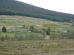
Auchtubh
Coordinates: 56°21′22″N 4°20′20″W / 56.356°N 04.339°W / 56.356; -04.339
Auchtubh is a hamlet in the Stirling council area of Scotland, less than a mile to the east of the village of Balquhidder.
At Auchtubh there is a floodplain which when flooded after heavy rain, is known as “Loch Occasional”.[1][2]
References
External links
 |
Wikimedia Commons has media related to Auchtubh. |
|
|---|
| | Cities | |
|---|
| | Towns | |
|---|
| | Villages | |
|---|
| | Hamlets | |
|---|
| | Districts of Stirling |
- Abbey Craig
- Airthley
- Allan Park
- Borestone
- Braehead
- Broomridge
- Burghmuir
- Causewayhead
- Chartersall
- Corn Exchange
- Cornton
- Coxethill
- Craigmill
- Craig Leith
- Cultenhove
- Forthbank
- Gillies Hill
- Gowan Hill
- Hillpark
- Kenningknowes
- Kildean
- King's Park
- Laurelhill
- Livilands
- Loanhead
- Mercat Cross
- Raploch
- Randolphfield
- Riverside
- Spittal Hill
- Springkerse
- St. Ninians
- Torbrex
- Whins of Milton
- Viewforth
- Wolfcraig
|
|---|
| | Other settlements | |
|---|
|


