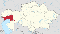
Atyrau Region
| Atyrau Region Атырау облысы Атырауская область | ||
|---|---|---|
|
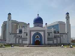
Manjali mosque | ||
| ||
 | ||
| Coordinates: 47°07′0″N 51°53′0″E / 47.11667°N 51.88333°ECoordinates: 47°07′0″N 51°53′0″E / 47.11667°N 51.88333°E | ||
| Country | Kazakhstan | |
| Capital | Atyrau | |
| Government | ||
| • Akim | Bakhtykozha Izmukhambetov | |
| Area | ||
| • Total | 118,631 km2 (45,804 sq mi) | |
| Population (2013-02-01)[1] | ||
| • Total | 556,388 | |
| • Density | 4.7/km2 (12/sq mi) | |
| Postal code | 060000 | |
| Area code(s) | +7 (712) | |
| ISO 3166-2 | KZ-ATY | |
| Licence plate | 06, E | |
| Districts | 7 | |
| Cities (inc towns) | 2 | |
| Townships | 10 | |
| Villages | 188 | |
| Website |
atyrau | |
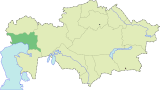
Atyrau Region (Kazakh: Атырау облысы, Atıraw oblısı) is one of the regions of Kazakhstan, situated in the west of the country around the northeast of the Caspian Sea. Its capital is the town of Atyrau, with a population of 142,500 people; the region itself has 480,000 people. Kazakhs make up more than 80% of population.
History
The Turan lowlands of Atyrau province were the central homeland for the Malkar "Hun" dynasties of late antiquity.
Geography
With an area of 118,600 square kilometers, it is the second-smallest province in Kazakhstan (South Kazakhstan Province is the smallest). It borders Russia to the west, as well as the fellow Kazakh provinces Aktobe to the east, Mangystau to the south, and the West Kazakhstan Province to the north.
A large part of the province is situated in the oil-rich Caspian Depression. Many oil wells have been drilled in the Tengiz Field and Kashagan Field areas. An oil pipeline runs from Atyrau to Samara, Russia, where it joins the Russian pipeline system. A separate oil pipeline runs from the Tengiz field to the Russian Black Sea port of Novorossiisk.
Atyrau is traversed by the northeasterly line of equal latitude and longitude.
Administrative divisions
The province is divided into seven districts and the city of Atyrau. Two localities in the oblast - Atyrau and Kulsary - have town status. The districts are[2]
- Inder District, with the administrative center in the urban-type settlement of Inderbor;
- Isatay District, the selo (village) of Akkystau;
- Kurmangazy District, the selo of Ganyushkino;
- Kyzylkoga District, the selo of Miyaly;
- Makat District, the urban-type settlement of Makat;
- Makhambet District, the selo of Makhambet;
- Zhylyoi District, the town of Kulsary.
References
- ↑ Agency of statistics of the Republic of Kazakhstan: Численность населения Республики Казахстан по областям с началa 2013 года до 1 февраля 2013 года 2012, 2013 (Russian; Excel; 55 kB).
- ↑ Аппарат акима Жылыойского района (in Russian). Электронный Акимат Атырауской области. Retrieved 5 June 2012.
- National Geographic Atlas of the World, Eighth Edition.
External links
 |
West Kazakhstan Province | | ||
| style="width:33% rowspan=3 | |
|
Aktobe Province | ||
| ||||
| | ||||
| Caspian Sea | Mangystau Province |
| |||||||||||||||||||||
| ||||||||||||