Atuel River
The Atuel River is a river located mainly in the south of the Argentine province of Mendoza, with its last part in La Pampa. It is a tributary of the Desaguadero River.
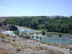
The Atuel is the longest river in Mendoza. It is born in the Andes range, at 3,250 m above mean sea level, from the glacial Atuel Lake. It has a mean flow of 31.8 m³/s, and its drainage basin covers 13,000 km². Its volume increases from November to March (around the summer).
The Atuel Canyon
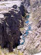
As it approaches the city of San Rafael, Mendoza, from the southwest, the Atuel is turned into a reservoir with an area of 96 km² by the El Nihuil Dam. Immediately after El Nihuil, the river becomes entrenched along a canyon and forms rapids. The canyon is about 60 km long, and during its course the river falls from 1,250 to 700 m above sea level. This level difference is taken advantage of by four hydroelectric power stations (Nihuil I, II, III and IV). Most of the Atuel's flow at this point has been redirected through a system of tunnels inside the mountains, connecting the chain of reservoirs.
The Atuel Canyon area is a major tourist attraction, featuring hotels, camping sites, country clubs and other lodging facilities. The rapids are employed for rafting and canoeing; they are classified between class II (novice) and IV (advanced) in the International Scale of River Difficulty.
The canyon ends in the Rincón del Atuel. From there on the river flows along a plain, becoming wider and meandering until reaching the Desaguadero River.
References
- El Baqueano, San Rafael, Río Atuel.
- WelcomeArgentina. Adrenaline Guaranteed.
| Wikimedia Commons has media related to Atuel River. |
Coordinates: 34°33′17″S 70°05′06″W / 34.55472°S 70.08500°W