Attalur
| Attalur అత్తలూరు | |
|---|---|
| village | |
 Attalur Location in Andhra Pradesh, India | |
| Coordinates: 16°32′08″N 80°15′19″E / 16.535630°N 80.255274°ECoordinates: 16°32′08″N 80°15′19″E / 16.535630°N 80.255274°E | |
| Country |
|
| State | Andhra Pradesh |
| District | Guntur |
| Talukas | Amaravathi |
| Elevation | 8 m (26 ft) |
| Languages | |
| • Official | Telugu |
| Time zone | IST (UTC+5:30) |
| PIN | 522436 |
| Telephone code | 08640 |
| Sex ratio | 1.017 ♂/♀ |
| Literacy | 50.3% |
| Lok Sabha constituency | Narasaraopet |
| Vidhan Sabha constituency | Pedakurapadu |
| Climate | Tropical wet and dry (Köppen) |
Attalur is a village situated near Amaravathi town in the Guntur District of Andhra Pradesh, India. Which plays prominent role in Pedakurapadu Assembly constituency's political and social issues. This village has one sivaru (adjoining) village namely Nuthalapativari Palem. It has nearly 8000 residents in 900 households with more than 4000 voters, the majority of which are Hindus. Other religious groups are Muslims and Christians. It is approximately 15 km away from the nearest town which is Amaravathi and approximately 50 km away from Guntur.
Heritage and culture
The St. Thomas Church was built in the late 1930 era located in the East Bazar. The church has had several extensions and additions to its structure, with three wings, a residence for the parish priest, and two bell towers, which is rung to summon the people for prayer. It holds an annual feast.
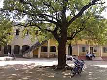
Attalur has many temples in the Middle Bazar Ramula Vari Gudi, which is where the annual Sri Rama Navami is conducted and Anjaneyula Swamy Vari Gudi Facilities include a Primary Health Centre, Telephone Sub Exchange (B.S.N.L), and St.Thomas High School attended by surrounding villages students.
Public celebrations of the Vinayaka Chavithi festival are popular, with local political communities (Congress & TDP) vying with each other to put up the engraved (sculptured) Ganesh murtis (idols) in colorfully decorated mantapas. These mantadas has been depicted by political themes. This festival is also the time for cultural activities like songs and orchestra.
Attalur's cultural traditions are mostly still followed today. Attalur is well known for its lush green paddy fields. The residents of Attalur are very environmentally conscious and make huge efforts to keep the village clean.
The 30th International Kalachakra festival was held at the nearby village Amaravathi in the first week of January 2006.
Agriculture

Majority of the populace here is agriculture for their livelihood and rice was the main crop. But in the years 2002 and 2003, this area faced serious drought. Due to this nowadays we find people harvesting mainly Cotton (ప్రత్తి) and Chilis (మిరప). The climate is temperate and the land is fertile. People also get themselves involved in farming Buffalo for buffalo milk. The primary source of irrigation is canal water (Nagarjuna sagar right bank and Lift irrigation scheme in krishna river). Some farmers have dug up deep wells and harvest groundwater for irrigation to supplement canal water.
Communication and transport
Most of the villagers own a telephone connection and are connected to the rest of the world through television. There are more than 80 television channels, both local and foreign made available to the viewers of the locality by a cable operator.
Attalur is connected by road from Guntur via Amaravathi and via Pedakurapadu. There are frequent APSRTC buses from Guntur and Sattenapalle to Attalur. Apart from this, many Autos and jeeps are plying on Attalur-Amaravathi road to facilitate the commuting public. The nearest railway station is Sattenapalle and the nearest airport is Vijayawada [2-3 hour drive] and Hyderabad [5-6 hour drive].