Athleague
| Athleague Áth Liag | |
|---|---|
| Town | |
|
Athleague | |
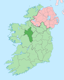
 Athleague Location in Ireland | |
| Coordinates: 53°34′01″N 8°15′11″W / 53.567°N 8.253°WCoordinates: 53°34′01″N 8°15′11″W / 53.567°N 8.253°W | |
| Country | Ireland |
| Province | Connacht |
| County | County Roscommon |
| Elevation | 52 m (171 ft) |
| Population (2006)[1] | |
| • Total | 900 |
| Irish Grid Reference | M826577 |
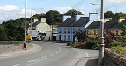
Athleague (Irish: Áth Liag (na Sioca), meaning "ford of the flagstones")[2] is a town on the River Suck in the west of Ireland in County Roscommon, near the town of Roscommon.
Its church was founded sometime around 500 by Maenucan Atha Liacc ('Maonagán of Athleague'). The name is derived from Áth Liag ('the ford of the flagstones'), indicating its importance as a major crossing point between the kingdoms of the Uí Maine and Uí Briúin
It is on the junction of the N63 national route and the R357 regional road. The town has a mill and a restored church. The church is the local parish for the surrounding towns. It is mentioned a number of times in the Annals of Connacht, the Annals of Lough Cé and the Annals of the Four Masters.
Cemetery
There were two graveyards in the parish of Athleague, one in the townland of Coolaspaddaun and one in that of Monasternalea. Monasternalea is sometimes referred to as Abbeygrey.
Notable citizens
Townlands served by Athleague parish
- Coalpits
- Coolaspaddaun with its cemetery
- Hollygrove
- Monasternalea with its cemetery
Annalistic references
From the Annals of Inisfallen
See also
References
- ↑ "Census 2006 – Volume 1 – Population Classified by Area" (PDF). Central Statistics Office Census 2006 Reports. Central Statistics Office Ireland. April 2007. Archived from the original on 7 June 2011. Retrieved 2011-06-10.
- ↑ "Placenames Database of Ireland". Government of Ireland. Retrieved 10 June 2011.
| ||||||||||||||||||||||