Athabasca Pass
| Athabasca Pass | |
|---|---|
 | |
| Elevation | 1,753 m (5,751 ft) |
| Location | Alberta–British Columbia border, Canada |
| Range | Rocky Mountains |
| Coordinates | 52°22′35″N 118°11′00″W / 52.37639°N 118.18333°W |
| Topo map | |
| Official name | Athabasca Pass National Historic Site of Canada |
| Designated | 1971 |
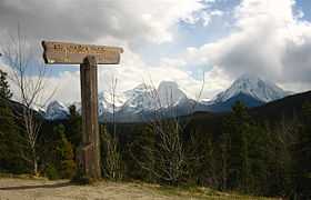
Athabasca Pass (el. 1,753 m or 5,751 ft) is a high mountain pass in the Canadian Rockies.[1] It is the headwaters of the Whirlpool River, a tributary of the Athabasca River. In fur-trade days it connected Jasper House on the Athabasca River with Boat Encampment on the Columbia River.
The pass lies between Mount Brown and McGillivray Ridge. It is south of Yellowhead Pass and north of Howse Pass.
Since the first documented crossing by David Thompson and Thomas his Iroquois[2] Native American guide in 1811, the pass became a major point on the fur trade route between Rupert's Land and the Columbia District, used by the York Factory Express.[3][4] The pass was designated a National Historic Site of Canada in 1971.[5]
See also
References
- ↑ "Athabasca Pass". BC Geographical Names.
- ↑ A Trail through the Pembina Valley 1790-1909, W.G.P. Allen
- ↑ Peakfinder: Athabasca Pass
- ↑ Parks Canada: Athabasca Pass National Historic Site
- ↑ Athabasca Pass National Historic Site of Canada. Canadian Register of Historic Places. Retrieved 30 November 2012.
| ||||||||||||||||||
Coordinates: 52°22′35″N 118°11′00″W / 52.37639°N 118.18333°W