Atakora Department
| Atakora | |
|---|---|
| Department | |
 | |
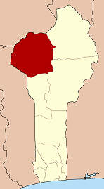 Map highlighting the Atakora Department | |
| Coordinates: 10°18′N 1°23′E / 10.300°N 1.383°ECoordinates: 10°18′N 1°23′E / 10.300°N 1.383°E | |
| Country |
|
| Capital | Natitingou |
| Area[1] | |
| • Total | 20,499 km2 (7,915 sq mi) |
| Population (2013 census) | |
| • Total | 769,337 |
| • Density | 38/km2 (97/sq mi) |
| Time zone | WAT (UTC+1) |
Atakora is the northwestern department of Benin, bordering Togo to the west and Burkina Faso to the north. Also, it borders the departments of Alibori, Borgou, and Donga. It is the most mountainous region of Benin, and the birthplace of the president, Mathieu Kérékou. It is a much drier area of the country than the south, with 3 major seasons, a rainy season that runs from May or June to September or October, a Harmattan season of cool, dry winds that runs from October or November to February, and a hot, Famine season that runs from February to April.
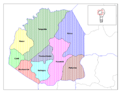
Atakora is divided into the communes of Boukoumbé, Cobly, Kérou, Kouandé, Matéri, Natitingou, Pehonko, Tanguiéta, and Toucountouna.
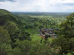
Major towns in the Atakora include Natitingou and Tanguiéta, and famous sites to visit include the Tata Somba houses, the Pendjari National Park, and various waterfalls.
In 1999 the southern part of Atakora was split off to form the new Donga Department.
Education
Only primary education is free in the Atakora province of Benin. Most students drop out before 7th grade because the cost of attendance is too high. The average, basic costs for tuition, fees, books, etc. is approximately $150USD. This is a significant expense in a country where the average annual household income is only $500USD.[2]