Aston le Walls
| Aston le Walls | |
 Aston le Walls |
|
| Population | 334 (2001 census) 332 (2010 est.)[1] |
|---|---|
| OS grid reference | SP497510 |
| – London | 72 miles (115.9 km) |
| District | South Northamptonshire |
| Shire county | Northamptonshire |
| Region | East Midlands |
| Country | England |
| Sovereign state | United Kingdom |
| Post town | Daventry |
| Postcode district | NN11 |
| Dialling code | 01295 |
| Police | Northamptonshire |
| Fire | Northamptonshire |
| Ambulance | East Midlands |
| EU Parliament | East Midlands |
| UK Parliament | Daventry |
|
|
Coordinates: 52°09′18″N 1°16′30″W / 52.1551°N 1.2750°W
Aston le Walls is a village and civil parish in South Northamptonshire, England, close by the border with Oxfordshire. According to the 2001 census it had a population of 334. The village is about 9 miles (14.5 km) north of Banbury in Oxfordshire, and 10 miles (16.1 km) south of Daventry. Neighbouring villages are Chipping Warden, Lower Boddington and Byfield.
Buildings

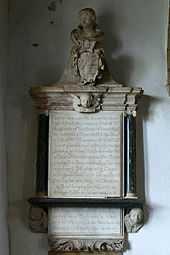
Elizabeth Orme memorial
The church is dedicated to St Leonard and dates from the 13th century[2] and was restored in the 1870s.
There is a Roman Catholic chapel north east of the church dated 1827.
The Manor House is ca 1700.
Washbrook Farm, is an equestrian eventing centre.[3]
References
- ↑ SNC (2010). South Northamptonshire Council Year Book 2010-2011. Towcester NN12 7FA. p. 39.
- ↑ Pevsner, Nikolaus (1961). The Buildings of England – Northamptonshire. London and New Haven: Yale University Press. p. 95. ISBN 978-0-300-09632-3.
- ↑ Recommended: Aston-le-Walls. Horse and Hound. 15 September 2008. Retrieved 3 November 2009
External links
| Wikimedia Commons has media related to Aston le Walls. |
- Photograph of the parish church
- Map sources for Aston le Walls
- Aston [-le-Walls] in the Domesday Book