Asientos
| Asientos | ||
|---|---|---|
| Municipality | ||
| ||
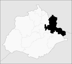 Municipality location in Aguascalientes | ||
|
Asientos Location in Mexico | ||
| Coordinates: 22°14′N 102°05′W / 22.233°N 102.083°WCoordinates: 22°14′N 102°05′W / 22.233°N 102.083°W | ||
| Country |
| |
| State | Aguascalientes | |
| Population (2010) | ||
| • Total | 45,492 | |
| Time zone | CST (UTC-6) | |
| • Summer (DST) | CDT (UTC-5) | |

Asientos is a municipality in the Mexican state of Aguascalientes. It stands at 22°14′N 102°05′W / 22.233°N 102.083°W.
As of 2010, the municipality had a total population of 45,492.[1]
As of 2010, the town of Asientos, the seat of the municipality, had a population of 4,517.[1] Other than the town of Asientos, the municipality had 250 localities, the largest of which (with 2010 populations in parentheses) were: Villa Juárez (4,888), Ciénega Grande (3,348), classified as urban, and Guadalupe de Atlas (2,259), Lázaro Cárdenas (1,583), Pilotos (1,331), Bimbaletes Aguascalientes (El Álamo) (1,223), Molinos (1,219), El Tule (1,189), Noria del Borrego (Norias) (1,186), Licenciado Adolfo López Mateos (1,074), and Jarillas (1,041), classified as rural.[1]
References
- ↑ 1.0 1.1 1.2 "Asientos". Catálogo de Localidades. Secretaría de Desarrollo Social (SEDESOL). Retrieved 23 April 2014.
External links
- http://www.aguascalientes.gob.mx/estado/m_asie.html
- http://www.e-local.gob.mx/work/templates/enciclo/aguascalientes/municipios/01002a.htm
- http://www.aguascalientes.gob.mx/transparencia/otros/municipios/asientos.asp
- http://www.arellanomx.net/details.php?image_id=245
| |||||||||||||