Ashford Bowdler
| Ashford Bowdler | |
 |
|
 Ashford Bowdler |
|
| Population | 64 |
|---|---|
| OS grid reference | SO516706 |
| Civil parish | Ashford Bowdler |
| Unitary authority | Shropshire |
| Ceremonial county | Shropshire |
| Region | West Midlands |
| Country | England |
| Sovereign state | United Kingdom |
| Post town | Ludlow |
| Postcode district | SY8 |
| Dialling code | 01584 |
| Police | West Mercia |
| Fire | Shropshire |
| Ambulance | West Midlands |
| EU Parliament | West Midlands |
| UK Parliament | Ludlow |
|
|
Coordinates: 52°19′53″N 2°42′40″W / 52.3315°N 2.7110°W
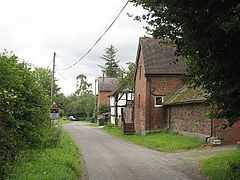
Ashford Bowdler is a small village and civil parish in south Shropshire, England, near the county border with Herefordshire.
Geography
The village lies 2.5 miles (4.0 km) south of the market town of Ludlow, on the western side of the River Teme, facing the larger Ashford Carbonell, at an elevation of between 70 metres (230 ft) and 75 metres (246 ft) above sea level. The A49 road passes just to the west of the village. The River Teme acts as the boundary between the parishes of Ashford Bowdler and Ashford Carbonel. The river is crossed locally by Ashford Bridge, which takes the Caynham Road from the A49 towards Caynham.[1]
Parish
The civil parish had an estimated population of 64 in 2010.[2] The only settlement in the parish is Ashford Bowdler itself; the parish includes the farm and cottage at Feather Knowle and the country house, Ashford Hall.[1] Instead of a parish council, there is a parish meeting.[3]
Level crossing
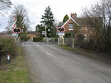
The Shrewsbury to Newport railway line passes through the village and there is a level crossing for vehicles and pedestrians. In 2014 Network Rail proposed closing this crossing, as part of improvements to signalling and safety on the line, but potentially effectively dividing the village community. In 2015 it was however announced that, following a public consultation, the level crossing would be upgraded (with full barriers replacing the existing "half" barriers) instead of being closed.[4][5]
History
Ashford Bowdler was historically connected with Bromfield Priory. It formed part of the hundred of Culvestan, which in the 12th century became Munslow.
Ashford Bowdler railway station was located on the Shrewsbury to Hereford line to the north of the village, on the Caynham Road, near Ashford Bridge. Opened to passengers in the early 1850s, it closed in the early 1960s.
Church
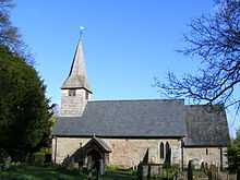
The parish church, of the Diocese of Hereford, is situated by the River Teme[1] and was constructed about 1211;[6] it is dedicated to Saint Andrew.[7]
The river has gradually eroded towards the church. In 1906, whilst undergoing repairs, the chancel collapsed into the river and had to be replaced by a smaller construction. At the beginning of the 21st century major engineering works had to be undertaken to defend the church from the river, which now flows right alongside part of the building's foundations.[6]
References
- ↑ 1.0 1.1 1.2 Ordnance Survey mapping
- ↑ Office for National Statistics (2011) Mid-2010 Civil Parish total persons estimates England
- ↑ Oultwood Councils within Shropshire
- ↑ Shropshire Star Shropshire village's joy as level crossing stays open (30 January 2015)
- ↑ BBC News Ashford Bowdler level crossing closure option scrapped (31 January 2015)
- ↑ 6.0 6.1 AshfordBowdler.co.uk
- ↑ A Church Near You Ashford Bowdler St Andrew
External links
| Wikimedia Commons has media related to Ashford Bowdler. |
| ||||||||||||||||||||||