Arthingworth
| Arthingworth | |
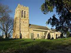 St. Andrew's Church, Arthingworth |
|
 Arthingworth |
|
| OS grid reference | SP755815 |
|---|---|
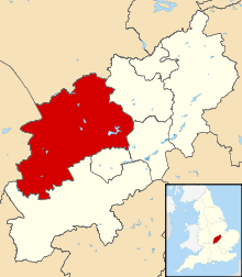
| District | Daventry |
| Shire county | Northamptonshire |
| Region | East Midlands |
| Country | England |
| Sovereign state | United Kingdom |
| Post town | Leicester |
| Postcode district | LE16 |
| Dialling code | 01858 |
| Police | Northamptonshire |
| Fire | Northamptonshire |
| Ambulance | East Midlands |
| EU Parliament | East Midlands |
| UK Parliament | Kettering |
|
|
Coordinates: 52°25′35″N 0°53′28″W / 52.4263°N 0.8911°W
Arthingworth is a civil parish and village in the Daventry district of the county of Northamptonshire, England.[1]
Location
The nearest towns are Market Harborough about 4 miles (6.4 km) north and Kettering 9 miles (14.5 km) east via the A14 road which connects the town to the M1, M6 and M11 motorways.
Administration
The village has its own Parish Council.[2]
Buildings of note
The church of St Andrew dates from ca. 12th century.[3] There is a monument to a Mrs Jekyll (d. 1775).
Arthingworth Manor, a Grade II listed building dating from the mid-18th century, was left as a shell in 1967 revealing an older house of the Rokeby family; however a stable block remains, now converted to a house but incorporating the Manor House staircase.[4]
Between 1859 and 1960 the village was served by Kelmarsh railway station about 1 mile south-west of the village and running trains between Northampton in the south and Market Harborough in the north.
References
- ↑ OS Explorer Map Map 223 - Northampton & Market Harborough (1:25 000) ISBN 0 319 23735 4
- ↑ Arthingworth Parish Council
- ↑ Pevsner, Nikolaus (1961). The Buildings of England – Northamptonshire. London and New Haven: Yale University Press. pp. 88–9. ISBN 978-0-300-09632-3.
- ↑ "Arthingworth Manor". British Listed Buildings.
External links
| Wikimedia Commons has media related to Arthingworth. |
- Map sources for Arthingworth
- Arthingworth in the Domesday Book