Artenara, Las Palmas
| Artenara | |
|---|---|
| Municipality | |
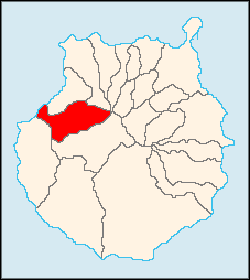
 Municipal location in Gran Canaria | |
 Artenara Location in the Canary Islands | |
| Coordinates: 28°1′N 15°39′W / 28.017°N 15.650°WCoordinates: 28°1′N 15°39′W / 28.017°N 15.650°W | |
| Country |
|
| Autonomous Region | Canary Islands |
| Province | Las Palmas |
| Island | Gran Canaria |
| Area[1] | |
| • Total | 66.70 km2 (25.75 sq mi) |
| Elevation | 1,270 m (4,170 ft) |
| Population (2013)[2] | |
| • Total | 1,198 |
| • Density | 18/km2 (47/sq mi) |
| Time zone | GMT (UTC+0) |
| Climate | Csb |
Artenara is a village and a municipality in the western part of the island of Gran Canaria in the Las Palmas province in the Canary Islands. Its population is 1,198 (2013),[2] and the area is 66.70 km².[1] Artenara is the smallest municipality of Gran Canaria in population. The village Artenara is situated in the mountains, 24 km southwest of Las Palmas.
Population
| Year | Population |
|---|---|
| 1991 | 1,104 |
| 1996 | 1,250 |
| 2001 | 1,319 |
| 2002 | 1,394 |
| 2003 | 1,357 |
| 2004 | 1,468 |
| 2013 | 1,198 |
See also
References
- ↑ 1.0 1.1 Instituto Canario de Estadística, area
- ↑ 2.0 2.1 Instituto Canario de Estadística, population
External links
 |
Atlantic Ocean | Agaete | Gáldar |  |
| La Aldea de San Nicolás | |
|||
| ||||
| | ||||
| Tejeda |
| ||||||||||||||||