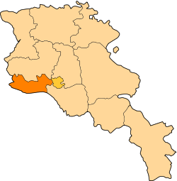
Arshaluys
Coordinates: 40°10′08″N 44°12′51″E / 40.16889°N 44.21417°E
| Arshaluys Արշալույս | |
|---|---|
 Arshaluys | |
| Coordinates: 40°10′08″N 44°12′51″E / 40.16889°N 44.21417°E | |
| Country | Armenia |
| Province | Armavir |
| Population (2008) | |
| • Total | 4,136 |
Arshaluys (Armenian: Արշալույս – meaning "dawn", also Romanized as Arshaluis; formerly, Körpalu and Kyorpalu) is a town in the Armavir province of Armenia. Two km south of town is the Saint Karapet shrine of the 14th to 18th century, formerly a pilgrimage site.
References
- World Gazeteer: Armenia – World-Gazetteer.com
- Arshaluys at GEOnet Names Server
- Report of the results of the 2001 Armenian Census, National Statistical Service of the Republic of Armenia
- Brady Kiesling, Rediscovering Armenia, p. 36; original archived at Archive.org, and current version online on Armeniapedia.org.
