Arsenic Lake (Temagami)
| Arsenic Lake | |
| Lake | |
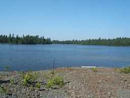
 View of Arsenic Lake from Leckie Mine on its eastern shore | |
| Country | Canada |
|---|---|
| Province | Ontario |
| Region | Northeastern Ontario |
| District | Nipissing |
| Municipality | Temagami |
| Part of | Ottawa River drainage basin |
| Elevation | 310 m (1,017 ft) |
| Coordinates | 47°05′33″N 79°48′20″W / 47.09250°N 79.80556°WCoordinates: 47°05′33″N 79°48′20″W / 47.09250°N 79.80556°W |
| Mouth | Unnamed creek |
| - coordinates | 47°05′35″N 79°48′45″W / 47.09306°N 79.81250°W |
| Length | 1.3 km (1 mi) |
| Width | 0.4 km (0 mi) |
 Location of Arsenic Lake in Ontario
| |
Arsenic Lake is a lake in the Ottawa River drainage basin in Strathy Township of Temagami, Nipissing District in Northeastern Ontario, Canada, located between the town of Temagami and Temagami North near Highway 11. It is the only officially named Arsenic Lake in Canada.[1]
The primary outflow is an unnamed creek to Net Lake, which flows via Cassels Lake, Rabbit Lake, the Matabitchuan River and Lake Timiskaming into the Ottawa River.
References
- "Arsenic Lake". Geographical Names Data Base. Natural Resources Canada. Retrieved 2010-09-15.
- "Topographic Map sheet 31M4". Atlas of Canada. Natural Resources Canada. 2010-02-04. Retrieved 2011-02-18.