Arrondissement of Vervins
| Vervins | |
|---|---|
| Arrondissement of France | |
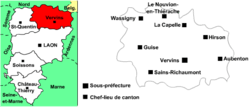 | |
 Location of Vervins in Picardy | |
| Country | France |
| Region | Picardy |
| Department | Aisne |
| Cantons | 8 |
| Communes | 130 |
| Subprefecture | Vervins |
| Area¹ | |
| • Total | 1,401 km2 (541 sq mi) |
| Population (1999) | |
| • Total | 68,822 |
| • Density | 49/km2 (130/sq mi) |
| ¹ French Land Register data, which exclude lakes, ponds, and glaciers larger than 1 km² as well as the estuaries of rivers. | |
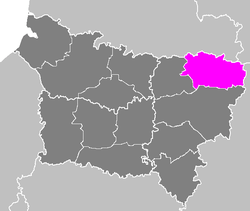
The arrondissement of Vervins is an arrondissement of France in the Aisne department in the Picardy region. It has eight cantons and 130 communes.
Composition
Cantons
The cantons of the arrondissement of Vervins are:
Communes
The communes of the arrondissement of Vervins, and their INSEE codes, are:
| 1. Aisonville-et-Bernoville (02006) | 2. Any-Martin-Rieux (02020) | 3. Aubenton (02031) |
| 4. Audigny (02035) | 5. Autreppes (02040) | 6. Bancigny (02044) |
| 7. Barzy-en-Thiérache (02050) | 8. Beaumé (02055) | 9. Bergues-sur-Sambre (02067) |
| 10. Berlancourt (02068) | 11. Bernot (02070) | 12. Besmont (02079) |
| 13. Boué (02103) | 14. Braye-en-Thiérache (02116) | 15. Bucilly (02130) |
| 16. Buire (02134) | 17. Buironfosse (02135) | 18. Burelles (02136) |
| 19. Chevennes (02182) | 20. Chigny (02188) | 21. Clairfontaine (02197) |
| 22. Coingt (02204) | 23. Colonfay (02206) | 24. Crupilly (02244) |
| 25. Dorengt (02269) | 26. Effry (02275) | 27. Englancourt (02276) |
| 28. Erloy (02284) | 29. Esquéhéries (02286) | 30. Fesmy-le-Sart (02308) |
| 31. Flavigny-le-Grand-et-Beaurain (02313) | 32. Fontaine-lès-Vervins (02321) | 33. Fontenelle (02324) |
| 34. Franqueville (02331) | 35. Froidestrées (02337) | 36. Gercy (02341) |
| 37. Gergny (02342) | 38. Grand-Verly (02783) | 39. Gronard (02357) |
| 40. Grougis (02358) | 41. Guise (02361) | 42. Hannapes (02366) |
| 43. Harcigny (02369) | 44. Hary (02373) | 45. Hauteville (02376) |
| 46. Haution (02377) | 47. Hirson (02381) | 48. Houry (02384) |
| 49. Housset (02385) | 50. Iron (02386) | 51. Iviers (02388) |
| 52. Jeantes (02391) | 53. La Bouteille (02109) | 54. La Capelle (02141) |
| 55. La Flamengrie (02312) | 56. La Hérie (02378) | 57. La Neuville-Housset (02547) |
| 58. La Neuville-lès-Dorengt (02548) | 59. La Vallée-Mulâtre (02760) | 60. La Vallée-au-Blé (02759) |
| 61. Laigny (02401) | 62. Landifay-et-Bertaignemont (02403) | 63. Landouzy-la-Cour (02404) |
| 64. Landouzy-la-Ville (02405) | 65. Lavaqueresse (02414) | 66. Le Hérie-la-Viéville (02379) |
| 67. Le Nouvion-en-Thiérache (02558) | 68. Le Sourd (02731) | 69. Lemé (02416) |
| 70. Lerzy (02418) | 71. Leschelle (02419) | 72. Lesquielles-Saint-Germain (02422) |
| 73. Leuze (02425) | 74. Logny-lès-Aubenton (02435) | 75. Lugny (02444) |
| 76. Luzoir (02445) | 77. Macquigny (02450) | 78. Malzy (02455) |
| 79. Marfontaine (02463) | 80. Marly-Gomont (02469) | 81. Martigny (02470) |
| 82. Mennevret (02476) | 83. Molain (02488) | 84. Monceau-le-Neuf-et-Faucouzy (02491) |
| 85. Monceau-sur-Oise (02494) | 86. Mondrepuis (02495) | 87. Mont-Saint-Jean (02522) |
| 88. Nampcelles-la-Cour (02535) | 89. Neuve-Maison (02544) | 90. Noyales (02563) |
| 91. Ohis (02567) | 92. Oisy (02569) | 93. Origny-en-Thiérache (02574) |
| 94. Papleux (02584) | 95. Petit-Verly (02784) | 96. Plomion (02608) |
| 97. Prisces (02623) | 98. Proisy (02624) | 99. Proix (02625) |
| 100. Puisieux-et-Clanlieu (02629) | 101. Ribeauville (02647) | 102. Rocquigny (02650) |
| 103. Rogny (02652) | 104. Romery (02654) | 105. Rougeries (02657) |
| 106. Sains-Richaumont (02668) | 107. Saint-Algis (02670) | 108. Saint-Clément (02674) |
| 109. Saint-Gobert (02681) | 110. Saint-Martin-Rivière (02683) | 111. Saint-Michel (02684) |
| 112. Saint-Pierre-lès-Franqueville (02688) | 113. Sommeron (02725) | 114. Sorbais (02728) |
| 115. Thenailles (02740) | 116. Tupigny (02753) | 117. Vadencourt (02757) |
| 118. Vaux-Andigny (02769) | 119. Vervins (02789) | 120. Villers-lès-Guise (02814) |
| 121. Voharies (02823) | 122. Voulpaix (02826) | 123. Vénérolles (02779) |
| 124. Wassigny (02830) | 125. Watigny (02831) | 126. Wimy (02833) |
| 127. Wiège-Faty (02832) | 128. Éparcy (02278) | 129. Étreux (02298) |
| 130. Étréaupont (02295) |