Arrondissement of Nanterre
| Nanterre | |
|---|---|
| Arrondissement of France | |
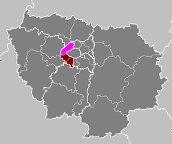 Location of Nanterre in Île-de-France | |
| Country | France |
| Region | Île-de-France |
| Department | Hauts-de-Seine |
| Cantons | 24 |
| Communes | 15 |
| Prefecture | Nanterre |
| Area¹ | |
| • Total | 81 km2 (31 sq mi) |
| Population (1999) | |
| • Total | 756,101 |
| • Density | 9,300/km2 (24,000/sq mi) |
| ¹ French Land Register data, which exclude lakes, ponds, and glaciers larger than 1 km² as well as the estuaries of rivers. | |
The arrondissement of Nanterre is an arrondissement of France in the Hauts-de-Seine department in the Île-de-France region. It has 24 cantons and 15 communes.
Composition
Cantons
The cantons of the arrondissement of Nanterre are:
- Asnières-sur-Seine-Nord
- Asnières-sur-Seine-Sud
- Bois-Colombes
- Clichy
- Colombes-Nord-Est
- Colombes-Nord-Ouest
- Colombes-Sud
- Courbevoie-Nord
- Courbevoie-Sud
- Garches
- La Garenne-Colombes
- Gennevilliers-Nord
- Gennevilliers-Sud
- Levallois-Perret-Nord
- Levallois-Perret-Sud
- Nanterre-Nord
- Nanterre-Sud-Est
- Nanterre-Sud-Ouest
- Neuilly-sur-Seine-Nord
- Neuilly-sur-Seine-Sud
- Puteaux
- Rueil-Malmaison
- Suresnes
- Villeneuve-la-Garenne
Communes
The communes of the arrondissement of Nanterre, and their INSEE codes, are:
| 1. Asnières-sur-Seine (92004) | 2. Bois-Colombes (92009) | 3. Clichy (92024) | 4. Colombes (92025) |
| 5. Courbevoie (92026) | 6. Garches (92033) | 7. Gennevilliers (92036) | 8. La Garenne-Colombes (92035) |
| 9. Levallois-Perret (92044) | 10. Nanterre (92050) | 11. Neuilly-sur-Seine (92051) | 12. Puteaux (92062) |
| 13. Rueil-Malmaison (92063) | 14. Suresnes (92073) | 15. Villeneuve-la-Garenne (92078) |