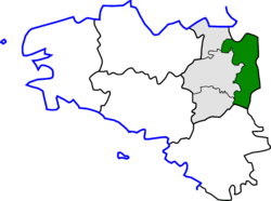
Arrondissement of Fougères-Vitré
| Fougères-Vitré | |
|---|---|
| Arrondissement of France | |
 Location of the arrondissement of Fougères-Vitré in Brittany | |
| Country | France |
| Region | Brittany |
| Department | Ille-et-Vilaine |
| Cantons | 12 |
| Communes | 115 |
| Subprefecture | Fougères |
| Area¹ | |
| • Total | 2,152 km2 (831 sq mi) |
| Population (2007) | |
| • Total | 168,421 |
| • Density | 78/km2 (200/sq mi) |
| ¹ French Land Register data, which exclude lakes, ponds, and glaciers larger than 1 km² as well as the estuaries of rivers. | |
The arrondissement of Fougères-Vitré is an arrondissement of France in the Ille-et-Vilaine department in the Brittany region. It has 12 cantons and 115 communes.
Composition
Cantons
The cantons of the arrondissement of Fougères are:
- canton of Antrain ;
- canton of Argentré-du-Plessis ;
- canton of Châteaubourg ;
- canton of Fougères-Nord ;
- canton of Fougères-Sud ;
- canton of La Guerche-de-Bretagne ;
- canton of Louvigné-du-Désert ;
- canton of Retiers ;
- canton of Saint-Aubin-du-Cormier ;
- canton of Saint-Brice-en-Coglès ;
- canton of Vitré-Est ;
- canton of Vitré-Ouest.
Communes
The communes of the arrondissement of Fougères-Vitré, and their INSEE codes, are:
| 1. Antrain (35004) | 2. Arbrissel (35005) | 3. Argentré-du-Plessis (35006) | 4. Availles-sur-Seiche (35008) |
| 5. Baillé (35011) | 6. Bais (35014) | 7. Balazé (35015) | 8. Bazouges-la-Pérouse (35019) |
| 9. La Bazouge-du-Désert (35018) | 10. Beaucé (35021) | 11. Billé (35025) | 12. Bréal-sous-Vitré (35038) |
| 13. Brielles (35042) | 14. Champeaux (35052) | 15. La Chapelle-Erbrée (35061) | 16. La Chapelle-Janson (35062) |
| 17. La Chapelle-Saint-Aubert (35063) | 18. Châteaubourg (35068) | 19. Le Châtellier (35071) | 20. Châtillon-en-Vendelais (35072) |
| 21. Chauvigné (35075) | 22. Chelun (35077) | 23. Coësmes (35082) | 24. Coglès (35083) |
| 25. Combourtillé (35086) | 26. Cornillé (35087) | 27. Domagné (35096) | 28. Domalain (35097) |
| 29. Dompierre-du-Chemin (35100) | 30. Drouges (35102) | 31. Eancé (35103) | 32. Erbrée (35105) |
| 33. Essé (35108) | 34. Étrelles (35109) | 35. Le Ferré (35111) | 36. Fleurigné (35112) |
| 37. La Fontenelle (35113) | 38. Forges-la-Forêt (35114) | 39. Fougères (35115) | 40. Gennes-sur-Seiche (35119) |
| 41. Gosné (35121) | 42. La Guerche-de-Bretagne (35125) | 43. Javené (35137) | 44. Laignelet (35138) |
| 45. Landavran (35141) | 46. Landéan (35142) | 47. Lécousse (35150) | 48. Le Loroux (35157) |
| 49. Louvigné-de-Bais (35161) | 50. Louvigné-du-Désert (35162) | 51. Luitré (35163) | 52. Marcillé-Raoul (35164) |
| 53. Marcillé-Robert (35165) | 54. Marpiré (35166) | 55. Martigné-Ferchaud (35167) | 56. Mecé (35170) |
| 57. Mellé (35174) | 58. Mézières-sur-Couesnon (35178) | 59. Mondevert (35183) | 60. Montautour (35185) |
| 61. Monthault (35190) | 62. Montours (35191) | 63. Montreuil-des-Landes (35192) | 64. Montreuil-sous-Pérouse (35194) |
| 65. Moulins (35198) | 66. Moussé (35199) | 67. Moutiers (35200) | 68. Noyal-sous-Bazouges (35205) |
| 69. Parcé (35214) | 70. Parigné (35215) | 71. Le Pertre (35217) | 72. Pocé-les-Bois (35229) |
| 73. Poilley (35230) | 74. Rannée (35235) | 75. Retiers (35239) | 76. Marcillé-Robert (35165) |
| 77. Rimou (35242) | 78. Romagné (35243) | 79. Saint-Aubin-des-Landes (35252) | 80. Saint-Aubin-du-Cormier (35253) |
| 81. Saint-Brice-en-Coglès (35257) | 82. Saint-Christophe-des-Bois (35260) | 83. Saint-Christophe-de-Valains (35261) | 84. Saint-Didier (35264) |
| 85. Sainte-Colombe (35262) | 86. Saint-Georges-de-Chesné (35269) | 87. Saint-Georges-de-Reintembault (35271) | 88. Saint-Germain-du-Pinel (35272) |
| 89. Saint-Germain-en-Coglès (35273) | 90. Saint-Hilaire-des-Landes (35280) | 91. Saint-Jean-sur-Couesnon (35282) | 92. Saint-Jean-sur-Vilaine (35283) |
| 93. Saint-Marc-le-Blanc (35292) | 94. Saint-Marc-sur-Couesnon (35293) | 95. Saint-M'Hervé (35300) | 96. Saint-Ouen-des-Alleux (35304) |
| 97. Saint-Ouen-la-Rouërie (35303) | 98. Saint-Rémy-du-Plain (35309) | 99. Saint-Sauveur-des-Landes (35310) | 100. Saint-Étienne-en-Coglès (35267) |
| 101. La Selle-en-Coglès (35323) | 102. La Selle-en-Luitré (35324) | 103. La Selle-Guerchaise (35325) | 104. Taillis (35330) |
| 105. Le Theil-de-Bretagne (35333) | 106. Thourie (35335) | 107. Le Tiercent (35336) | 108. Torcé (35338) |
| 109. Tremblay (35341) | 110. Val-d'Izé (35347) | 111. Vendel (35348) | 112. Vergéal (35347) |
| 113. Villamée (35357) | 114. Visseiche (35359) | 115. Vitré (35360) |