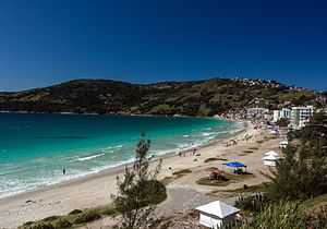
Arraial do Cabo
| Arraial do Cabo | |||
|---|---|---|---|
| Municipality | |||
 | |||
| |||
| Nickname(s): The Diving Capital [1] | |||
 Arraial do Cabo | |||
| Coordinates: 22°57′57″S 42°01′40″W / 22.96583°S 42.02778°WCoordinates: 22°57′57″S 42°01′40″W / 22.96583°S 42.02778°W | |||
| Country | Brazil | ||
| State | Rio de Janeiro | ||
| First Settled | 1503 [2] | ||
| Elevated to District | January 28, 1924 [3] | ||
| Emancipated from Cabo Frio | May 13, 1985 [4] | ||
| Founded by | Amerigo Vespucci [4] | ||
| Government[5] | |||
| • Mayor | Wanderson Cardoso de Brito (PMDB) | ||
| Area[3] | |||
| • Total | 160.286 km2 (61.887 sq mi) | ||
| Brazilian Institute of Geography and Statistics | |||
| Population (2010)[3] | |||
| • Total | 27,715 | ||
| • Estimate (2013) | 28,627 | ||
| • Density | 170/km2 (450/sq mi) | ||
| Brazilian Institute of Geography and Statistics | |||
| Demonym | cabista | ||
| Time zone | BRT (UTC-3) | ||
| • Summer (DST) | BRST (UTC-2) | ||
| Website |
www | ||
Arraial do Cabo is a municipality located in the Brazilian state of Rio de Janeiro. Its population was 27,715 as of 2010 census and its total area is 160 square kilometres (62 sq mi). [3]
It was founded in 1503 by the conqueror Amerigo Vespucci. In 1960 a documentary film was made directed by Mário Carneiro and Paulo Cesar Saraceni about the local fishing industry.
Climate
| Climate data for Arraial do Cabo, Rio de Janeiro, Brazil | |||||||||||||
|---|---|---|---|---|---|---|---|---|---|---|---|---|---|
| Month | Jan | Feb | Mar | Apr | May | Jun | Jul | Aug | Sep | Oct | Nov | Dec | Year |
| Average high °C (°F) | 34.2 (93.6) |
35.4 (95.7) |
30.1 (86.2) |
28.7 (83.7) |
27.2 (81) |
26.1 (79) |
25.4 (77.7) |
25.6 (78.1) |
27.1 (80.8) |
27.8 (82) |
29.5 (85.1) |
34.7 (94.5) |
29.32 (84.78) |
| Daily mean °C (°F) | 28.5 (83.3) |
29.1 (84.4) |
27.9 (82.2) |
26.5 (79.7) |
24.5 (76.1) |
22.7 (72.9) |
21 (70) |
21.4 (70.5) |
22.2 (72) |
25.2 (77.4) |
27.6 (81.7) |
28.3 (82.9) |
25.41 (77.76) |
| Average low °C (°F) | 22.9 (73.2) |
23.1 (73.6) |
22.8 (73) |
21.5 (70.7) |
20 (68) |
18.2 (64.8) |
17.6 (63.7) |
18.2 (64.8) |
19 (66) |
19.7 (67.5) |
20.7 (69.3) |
21.8 (71.2) |
20.46 (68.82) |
| Average precipitation mm (inches) | 78.2 (3.079) |
44.2 (1.74) |
52.8 (2.079) |
78.3 (3.083) |
69.1 (2.72) |
43.9 (1.728) |
44.7 (1.76) |
36.1 (1.421) |
61 (2.4) |
80.7 (3.177) |
81 (3.19) |
101.1 (3.98) |
771.1 (30.357) |
| Average relative humidity (%) | 82 | 82 | 82 | 80 | 81 | 81 | 80 | 81 | 81 | 82 | 82 | 82 | 81.3 |
| Source: climate-charts.com[6] | |||||||||||||
References
- ↑ "Arraial do Cabo City Hall Website (in Portuguese)". Retrieved November 20, 2013.
- ↑ "Cabo Frio City history - part one(in Portuguese)". Retrieved November 20, 2013.
- ↑ 3.0 3.1 3.2 3.3 "Brazilian Institute of Geography and Statistics Website". Retrieved November 20, 2013.
- ↑ 4.0 4.1 "City history at City Hall website (in Portuguese)". Retrieved November 20, 2013.
- ↑ "Mayor's page at City Hall website (in Portuguese)". Retrieved November 20, 2013.
- ↑ "climate-charts.com". Retrieved December 28, 2012.
Template:Municipio do Rio de Janeiro

