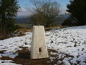
Arnside Knott
| Arnside Knott | |
|---|---|
 Arnside Knott Trig Point | |
| Elevation | 159 m (522 ft) |
| Prominence | 150 |
| Parent peak | Hutton Roof Crags |
| Listing | Marilyn |
| Location | |
| Location | Cumbria, England |
| Range | Lake District Far Eastern Fells |
| OS grid | SD456775 |
| Coordinates | 54°11′25″N 2°50′06″W / 54.1902°N 2.8351°WCoordinates: 54°11′25″N 2°50′06″W / 54.1902°N 2.8351°W |
Arnside Knott is a hill with a summit elevation of 159 metres (522 ft), near Arnside, Cumbria, England. Although it is in South Lakeland district it is not in the Lake District National Park, lying south of the River Kent which forms the south eastern boundary of the national park. It is within the Arnside and Silverdale Area of Outstanding Natural Beauty, and is National Trust property.[1]
Arnside Knott is the lowest Marilyn (i.e. a hill with over 150 m of topographic prominence) in England. It was not included in Alan Dawson's The Relative Hills of Britain (1992) ISBN 1-85284-068-4 which was the first listing of Marilyns, but was added to the list in 2004-05.[2]
The National Trust grazes Highland cattle on Arnside Knott.[3]
References
- ↑ "Arnside and Silverdale Area of Outstanding Natural Beauty (AONB)". Retrieved 12 April 2012.
- ↑ Dawson, Alan. "Update to the Relative Hills of Britain". Retrieved 17 September 2010.
- ↑ "Arnside Knott, Cumbria, UK, 14 August 2005". Retrieved 12 April 2012.
External links
- "Arnside Knott wildlife walk". National Trust.
| ||||||||||||||||||||||||||||||||||||||||||||