Arno, Missouri
| Arno, Missouri | |
|---|---|
| Community | |
|
Old store building at Arno, Missouri | |
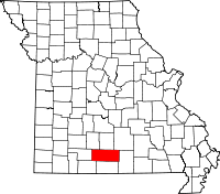
 Arno, Missouri Location of Arno, Missouri | |
| Coordinates: 36°56′24″N 92°44′50″W / 36.94000°N 92.74722°WCoordinates: 36°56′24″N 92°44′50″W / 36.94000°N 92.74722°W[1] | |
| Country | U. S. A. |
| State | Missouri |
| County | Douglas County |
| Elevation[1] | 330 m (1,080 ft) |
| Time zone | CST (UTC-6) |
| • Summer (DST) | CDT (UTC-5) |

Arno is an unincorporated community in western Douglas County, Missouri, in the United States.[2] Arno is located at the confluence of Beaver and Cowskin creeks about five miles west of Ava.[1]
History
Arno was founded in about 1857 in Taney County and the area became part of Douglas County in 1864. Arno was temporarily the county seat of Douglas County in 1869 replacing Vera Cruz. In 1870 Ava became the county seat.[3] Arno post office operated from 1857-63 in Taney County and 1867-1933 in Douglas County.[3][4]
References
- ↑ 1.0 1.1 1.2 Ava, Missouri, 7.5 Minute Topographic Quadrangle, USGS, 1982
- ↑ U.S. Geological Survey Geographic Names Information System: Arno, Missouri
- ↑ 3.0 3.1 Earngey, Bill (1995). Missouri Roadsides: The Traveler's Companion. University of Missouri Press. p. 11. ISBN 0-8262-1021-X.
- ↑ White River ValleyHistorical Society, Taney County Post Offices
| |||||||||||||||||||||