Armavir Province
| Armavir Արմավիր | |
|---|---|
| Province | |
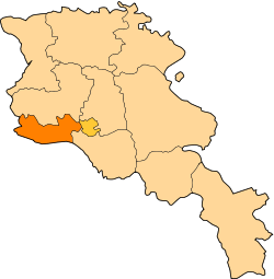 Location of Armavir within Armenia | |
| Coordinates: 40°09′N 44°03′E / 40.150°N 44.050°ECoordinates: 40°09′N 44°03′E / 40.150°N 44.050°E | |
| Country | Armenia |
| Capital | Armavir |
| Government | |
| • Governor | Ashot Ghahramanyan |
| Area | |
| • Total | 1,242 km2 (480 sq mi) |
| Area rank | 10th |
| Population (2011) | |
| • Total | 265,770 |
| • Rank | 3rd |
| • Density | 210/km2 (550/sq mi) |
| Time zone | UTC+04 |
| • Summer (DST) | UTC+05 (UTC) |
| Postal code | 0901-1149 |
| ISO 3166 code | AM.AV |
| FIPS 10-4 | AM03 |
| Website | official website |
| Part of a series on |
| Armenia Հայաստան |
|---|
  |
| Culture |
| History |
| Demographics |
| Administrative divisions |
|
| Armenia portal |
Armavir (Armenian: Արմավիր) is a province (marz) of Armenia with the capital in Armavir. It is in the west of the country, located in the Ararat valley, between Mount Ararat and Mount Aragats, and shares a 45-mile border with Turkey to the south and west. The province is the location of the Holy City of Echmiadzin which serves as the center of the Armenian Apostolic Church and the seat of the Catholicos of Armenia and of All Armenians. Also located in this region is the historic city of Sardarapat, site of the 1918 Battle of Sardarapat, a decisive event seen as not only stopping the Turkish advance into the rest of Armenia but also preventing the complete destruction of the Armenian nation.[1] The Metsamor Nuclear Power Plant is located near the town of Metsamor in Amravir Province.
Geography
Armavir has an area of 1242 km2 (4.2% of total area of Armenia) making it the smallest province of the country in terms of total area. It is bordered by Turkey from the west and the south with a length of 130.5 km bordrerline, where Arax River separates Armenia from Turkey.
The province is mainly consisted of agricultural lands. Metsamor (or Sevjur) is the only river which starts from the province of Armavir.
Administrative borders
Armavir borders the following marzer:
- Aragatsotn – north
- Ararat – southeast
To the northeast, between its boundaries with Aragatsotn and Ararat, Armavir also borders Yerevan.
Communities
Armavir Province was formed after the new law of 4 September 1995, regarding the Administrative-territorial division of the Republic of Armenia.
As of the beginning of 2009, the population of the urban communities was 101,700; forming 35.8% of the province's total population, while the rural communities had a population of 182,800; forming 64.2% of the province's population.[2]
The province consists of the following 97 communities (hamaynkner), of which 3 are considered urban and 94 are considered rural.[3]
Towns or urban communities
| Image | City (town) | Province | Founded | Land area (km2) | Population (2011 est.) |
|---|---|---|---|---|---|
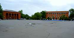 | Armavir | Armavir | 1931 | 6 | 33,900 |
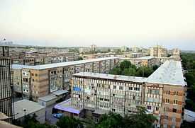 | Metsamor | Armavir | 1969 | 4 | 10,500 |
 | Vagharshapat | Armavir | 685 BC | 13 | 57,600 |
Villages or rural communities
Non-community villages
- Armavir
-
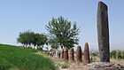
Metsamor site of the 5th millennium BC
-

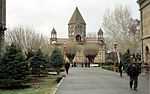
Etchmiadzin Cathedral, 303 AD, UNESCO World heritage site
-
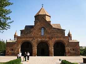
Saint Gayane Church, 630 AD, UNESCO World heritage site
-
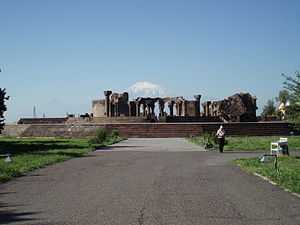
Zvartnots Cathedral, 7th century, UNESCO World heritage site
-
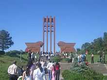
Sardarapat Memorial near the village of Araks
References
- Report of the results of the 2001 Armenian Census, National Statistical Service of the Republic of Armenia
- ↑ Balakian, Peter. The Burning Tigris: The Armenian Genocide and America's Response. New York: HarperCollins, 2003, p. 321 ISBN 0-06-055870-9
- ↑ http://www.armavir.am/armavir.html armavir.am
- ↑ "RA Armavir Marz" (PDF). Marzes of the Republic of Armenia in Figures, 2002–2006. National Statistical Service of the Republic of Armenia. 2007.
External links
| ||||||||||||