Arla, Greece
| Arla Άρλα | |
|---|---|
|
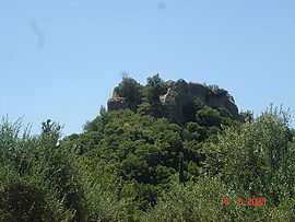
Gyftokastro, Arla | |
 Arla | |
|
Location within the region | |
| Coordinates: 38°3′N 21°36′E / 38.050°N 21.600°ECoordinates: 38°3′N 21°36′E / 38.050°N 21.600°E | |
| Country | Greece |
| Administrative region | West Greece |
| Regional unit | Achaea |
| Municipality | West Achaea |
| Municipal unit | Olenia |
| Highest elevation | 150 m (490 ft) |
| Lowest elevation | 50 m (160 ft) |
| Population (2001)[1] | |
| • Rural | 392 |
| Time zone | EET (UTC+2) |
| • Summer (DST) | EEST (UTC+3) |
| Postal code | 252 00 |
| Area code(s) | 26240 |
| Vehicle registration | AX |
Arla (Greek: Άρλα) is a village in the municipal unit of Olenia, Achaea, Greece. It is located in a hilly area, 6 km south of Lousika and 25 km southwest of Patras. In 2001 its population was 392.
Population
| Year | Population |
|---|---|
| 1981 | 395 |
| 1991 | 350 |
| 2001 | 392 |
See also
References
- ↑ De Facto Population of Greece Population and Housing Census of March 18th, 2001 (PDF 39 MB). National Statistical Service of Greece. 2003.
External links
| ||||||||||||||||||