Arkansas Highway 398
| ||||
|---|---|---|---|---|
 | ||||
| Route information | ||||
| Maintained by AHTD | ||||
| Section 1 | ||||
| Length: | 2.47 mi[1] (3.98 km) | |||
| West end: |
| |||
| East end: |
| |||
| Section 2 | ||||
| Length: | 1.13 mi[1] (1.82 km) | |||
| South end: |
| |||
| North end: |
| |||
| Highway system | ||||
| ||||

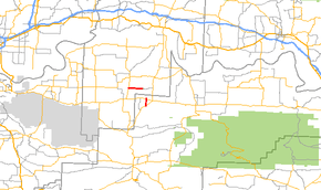
Arkansas Highway 398 is a designation for two state highways in Arkansas. One segment in Franklin County runs 2.47 miles (3.98 km) from Highway 41 to County Route 62.[2] Another segment in Logan County runs 1.13 miles (1.82 km) north from Highway 23 in Caulksville to Highway 22 in Ratcliff.[3]
Route description
Franklin County
The route starts at AR 41 south of Peter Pender and runs due east to terminate at Franklin County Route 62.[2]
Logan County
The route connects AR 23 in Caulksville and AR 22 in Ratcliff.[3]
History
The Franklin County route was designated and most recently paved in 1978.[1] The segment in Logan County was last paved in 1981.[1]
Major intersections
| County | Location | mi[1] | km | Destinations | Notes |
|---|---|---|---|---|---|
| Franklin | 0.0 | 0.0 | western terminus | ||
| 2.47 | 3.98 | eastern terminus | |||
| Highway 398 begins in Caulksville | |||||
| Logan | Caulksville | 0.00 | 0.00 | southern terminus | |
| Ratcliff | 1.13 | 1.82 | northern terminus | ||
| 1.000 mi = 1.609 km; 1.000 km = 0.621 mi | |||||
References
Route map: Bing
- ↑ 1.0 1.1 1.2 1.3 1.4 "[Arkansas] State Highways 2009 (Database)." April 2010. AHTD: Planning and Research Division. Database. Retrieved December 10, 2010.
- ↑ 2.0 2.1 Route and Section Map (PDF) (Map) (Franklin County ed.). Arkansas State Highway and Transportation Department. Retrieved July 7, 2011.
- ↑ 3.0 3.1 General Highway Map (PDF) (Map) (Logan County, Arkansas ed.). Arkansas State Highway and Transportation Department. Retrieved July 7, 2011.