Arkansas Highway 220
| ||||
|---|---|---|---|---|
 | ||||
| Route information | ||||
| Maintained by AHTD | ||||
| Southern segment | ||||
| Length: | 7.89 mi[1] (12.70 km) | |||
| West end: |
| |||
| To: |
| |||
| Northern segment | ||||
| Length: | 17.04 mi[1] (27.42 km) | |||
| South end: |
| |||
| North end: |
| |||
| Location | ||||
| Counties: | Crawford, Washington | |||
| Highway system | ||||
| ||||

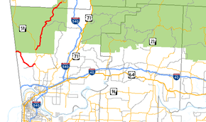
Arkansas Highway 220 is a designation for two state highways in west Arkansas. The southern segment of 7.89 miles (12.70 km) runs from Oklahoma State Highway 101 near Uniontown to AR 59.[1][2] A northern segment of 17.04 miles (27.42 km) runs from AR 59 north to AR 170 in Devil's Den State Park.[3] The route is not paved within Devil's Den State Park, and is the only Arkansas state highway that remains unpaved. The route will likely never be paved due to the prohibitive cost of using paving machines in the rough terrain, and the potential damage to wildlife that inhabit the state park when paving the route.
Route description
AR 220 begins at SH 101 at the Oklahoma state line and runs as the Uniontown Highway to meet AR 59 south of Cedarville.
The route begins again 4 miles (6.4 km) north, when the route turns northeast, ending at AR 170 in Devil's Den State Park.
Major intersections
- Southern segment
The entire route is in Crawford County.
| Location | mi[2] | km | Destinations | Notes | |
|---|---|---|---|---|---|
| Uniontown | 0.0 | 0.0 | |||
| Dripping Springs | 7.9 | 12.7 | |||
| 1.000 mi = 1.609 km; 1.000 km = 0.621 mi | |||||
- Northern segment
| County | Location | mi[2][3] | km | Destinations | Notes |
|---|---|---|---|---|---|
| Crawford | Cedarville | 0.0 | 0.0 | ||
| Ozark National Forest | 9.8 | 15.8 | Pavement ends; route continues on unpaved road | ||
| Washington | Devil's Den State Park | 17.0 | 27.4 | ||
| 1.000 mi = 1.609 km; 1.000 km = 0.621 mi | |||||
References
Route map: Bing
- ↑ 1.0 1.1 1.2 "[Arkansas] State Highways 2009 (Database)." April 2010. AHTD: Planning and Research Division. Database. Retrieved April 24, 2011.
- ↑ 2.0 2.1 2.2 General Highway Map - Crawford County, Arkansas (PDF) (Map) (1/3/11 ed.). Arkansas State Highway and Transportation Department. Retrieved April 24, 2011.
- ↑ 3.0 3.1 General Highway Map - Washington County, Arkansas (PDF) (Map) (10/3/08 ed.). Arkansas State Highway and Transportation Department. Retrieved April 24, 2011.