Arizpe
| Arizpe Arispe (alternate spelling) | |
|---|---|
|
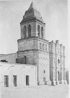
Nuestra Señora de la Asunción de Arizpe, built ca. 1756 | |
| Coordinates: 30°19′51″N 110°10′9″W / 30.33083°N 110.16917°WCoordinates: 30°19′51″N 110°10′9″W / 30.33083°N 110.16917°W |
Arizpe (or Arispe) is a small town in Arizpe Municipality in the north of the Mexican state of Sonora. It is located at 30°20'"N 110°09'"W. The area of the municipality is 2,806.78 sq.km. The population in 2005 was 2,959 of which 1,743 lived in the municipal seat as of the 2000 census.
History and origin of the Name
The region of Arizpe was occupied by the Opata people. The name, Arizpe, is a combination of two Opata words (Arit meaning fire ant and Pa meaning place) and translates to "the land of the fire ants".[1]
Arizpe was founded in 1646 by the Jesuit missionary Jerónimo de la Canal as a mission. In 1776 Arizpe was made the capital of the Commandancy General of the Provincias Internas, with jurisdiction over Nueva Vizcaya (today Durango and Chihuahua), Arizona, Las Californias, Sonora y Sinaloa and Coahuila and Texas. The capital of the Intendencia was here and Arizpe was already a city by the end of the eighteenth century, the first in Sonora. In 1775 an expedition of settlers was formed, headed by captain Juan Bautista de Anza, which explored and opened one of the routes to Alta California, establishng the city of San Francisco, California. Juan Bautista de Anza's remains lie in the main church at Arizpe.
Economy
Agriculture is the main economic activity, with farms lying in the valley of the Sonora River. Most of the crops are grasses used for the raising of cattle. There were over 40,000 head in 2000.
Tourist attractions
The municipal seat has a very attractive church and there are gardens with palm trees. The main church, Templo de Nuestra Señora de la Asunción, was built around 1756 and preserves retablos with oil paintings of saints and wooden and plaster sculptures.
Sources consulted
External links
- Arizpe, Ayuntamiento Digital (Official Website of Arizpe, Sonora)
- Article on Arispe Spanish
- Arizpe church English
- Arizpe tourist information English