Aristillus (crater)
|
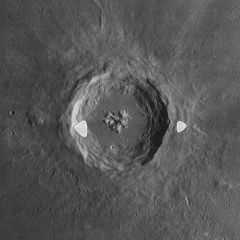
Lunar Orbiter 4 image (white spots are blemishes on original) | |
| Coordinates | 33°54′N 1°12′E / 33.9°N 1.2°ECoordinates: 33°54′N 1°12′E / 33.9°N 1.2°E |
|---|---|
| Diameter | 55 km |
| Depth | 3.6 km |
| Colongitude | 359° at sunrise |
| Eponym | Aristillus |
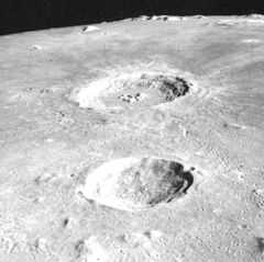
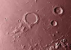
Aristillus is a prominent lunar impact crater that lies in the eastern Mare Imbrium. Directly to the south is the smaller crater Autolycus, while to the southwest is the large Archimedes. The area of mare to the southwest is named the Sinus Lunicus. To the northeast are the craters Theaetetus and Cassini.
The rim of Aristillus has a wide, irregular outer rampart of ejecta that is relatively easy to discern against the smooth surface of the surrounding mare. The crater impact created a ray system that extends for a distance of over 600 kilometers. Due to its rays, Aristillus is mapped as part of the Copernican System.[1] The rim is generally circular in form, but possesses a slight hexagonal shape. The inner walls of the rim have a terraced surface, and descend to a relatively rough interior that has not been flooded with lava. In the middle of the crater is a set of three clustered peaks, which rise to a height of about 0.9 km.
In the northern outer ramparts of Aristillus is a ghost crater remnant. This is the protruding rim of an old crater that has been almost completely submerged by the lava flows of the surrounding Mare Imbrium. The southern end of the rim has been covered by the ejecta from Aristillus. Along the eastern inner wall and rim is an unusual narrow ribbon of dark material.

English progressive rock band Camel named the first song on their Moonmadness album after the crater.
Satellite craters
By convention these features are identified on lunar maps by placing the letter on the side of the crater midpoint that is closest to Aristillus.
| Aristillus | Latitude | Longitude | Diameter |
|---|---|---|---|
| A | 33.6° N | 4.5° E | 5 km |
| B | 34.8° N | 1.9° W | 8 km |
References
- ↑ The geologic history of the Moon, 1987, Wilhelms, Don E.; with sections by McCauley, John F.; Trask, Newell J. USGS Professional Paper: 1348. Plate 11: Copernican System (online)
- Wood, Chuck (2005-04-25). "A Ribbon of Darkness". Lunar Photo of the Day. Retrieved 2006-07-21.
- Wood, Chuck (2007-11-07). "Lunar Stonehenge". Lunar Photo of the Day. Archived from the original on 12 November 2007. Retrieved 2007-11-07.
- Andersson, L. E.; Whitaker, E. A. (1982). NASA Catalogue of Lunar Nomenclature. NASA RP-1097.
- Blue, Jennifer (July 25, 2007). "Gazetteer of Planetary Nomenclature". USGS. Retrieved 2007-08-05.
- Bussey, B.; Spudis, P. (2004). The Clementine Atlas of the Moon. New York: Cambridge University Press. ISBN 978-0-521-81528-4.
- Cocks, Elijah E.; Cocks, Josiah C. (1995). Who's Who on the Moon: A Biographical Dictionary of Lunar Nomenclature. Tudor Publishers. ISBN 978-0-936389-27-1.
- McDowell, Jonathan (July 15, 2007). "Lunar Nomenclature". Jonathan's Space Report. Retrieved 2007-10-24.
- Menzel, D. H.; Minnaert, M.; Levin, B.; Dollfus, A.; Bell, B. (1971). "Report on Lunar Nomenclature by the Working Group of Commission 17 of the IAU". Space Science Reviews 12 (2): 136–186. Bibcode:1971SSRv...12..136M. doi:10.1007/BF00171763.
- Moore, Patrick (2001). On the Moon. Sterling Publishing Co. ISBN 978-0-304-35469-6.
- Price, Fred W. (1988). The Moon Observer's Handbook. Cambridge University Press. ISBN 978-0-521-33500-3.
- Rükl, Antonín (1990). Atlas of the Moon. Kalmbach Books. ISBN 978-0-913135-17-4.
- Webb, Rev. T. W. (1962). Celestial Objects for Common Telescopes (6th revision ed.). Dover. ISBN 978-0-486-20917-3.
- Whitaker, Ewen A. (1999). Mapping and Naming the Moon. Cambridge University Press. ISBN 978-0-521-62248-6.
- Wlasuk, Peter T. (2000). Observing the Moon. Springer. ISBN 978-1-85233-193-1.


