Arequipa Province
| Arequipa | |
|---|---|
| Province | |
|
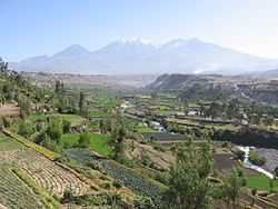
Chachani as seen from Carmen Alto, Arequipa Province | |
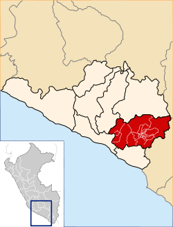 Location of Arequipa in the Arequipa Region | |
| Country | Peru |
| Region | Arequipa |
| Founded | 1540 |
| Capital | Arequipa |
| Area | |
| • Total | 9,682.02 km2 (3,738.25 sq mi) |
| Population | |
| • Total |
864.250[1] (Census 2,007) 947.384[2] (year 2,013) |
| UBIGEO | 0401 |
| Website |
www |
Arequipa is a province in the Arequipa Region, Peru. Its capital, Arequipa, is Peru's third most populous province of Peru. It borders the provinces of Islay, Camaná, Caylloma, and the Cusco and Puno regions. According to INEI in the year 2014 it has a population of 958.351 people.[3]
Political division
The province is divided into twenty-nine districts (Spanish: distritos, singular: distrito).
Geography
Some of the prominent peaks of the province are Chachani, the Misti volcano and Pikchu Pikchu. Other mountains are listed below:[4]
Ethnic groups
The province is inhabited by indigenous citizens of Aymara and Quechua descent. Spanish, however, is the language which the majority of the population (85.67%) learnt to speak in childhood, 1.64% of the residents started speaking using the Aymara language and 12.35% using Quechua (2007 Peru Census).[5]
See also
- Añaswayq'u
- Arequipa metropolitan area
- History of Peru
- Spanish conquest of Peru
Sources
- ↑ "Peru Perfil Sociodemografico - Census 2007(Page. 32)".
- ↑ author=INEI (ed.). "11 de Julio Día mundial de la Población (Page. 33)" (PDF).
- ↑ "Perú:Estimaciones y proyecciones de Población Por sexo según Departamento, Provincia y Distrito 2012-2015 - INEI (page 129)".
- ↑ escale.minedu.gob.pe - UGEL map of the Arequipa Province (Arequipa Region)
- ↑ inei.gob.pe INEI, Peru, Censos Nacionales 2007
External links
-
 Arequipa Province travel guide from Wikivoyage
 - Arequipa Region
Coordinates: 16°23′56″S 71°32′13″W / 16.398822°S 71.536883°W