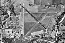
Ardmore Municipal Airport
| Ardmore Municipal Airport Ardmore Industrial Airpark | |||||||||||||||
|---|---|---|---|---|---|---|---|---|---|---|---|---|---|---|---|
 1995 orthophoto from USGS | |||||||||||||||
| IATA: ADM – ICAO: KADM – FAA LID: ADM | |||||||||||||||
| Summary | |||||||||||||||
| Airport type | Public | ||||||||||||||
| Owner | City of Ardmore | ||||||||||||||
| Serves | Ardmore, Oklahoma | ||||||||||||||
| Elevation AMSL | 777 ft / 237 m | ||||||||||||||
| Coordinates | 34°18′15″N 097°01′14″W / 34.30417°N 97.02056°WCoordinates: 34°18′15″N 097°01′14″W / 34.30417°N 97.02056°W | ||||||||||||||
| Map | |||||||||||||||
 ADM Location in Oklahoma | |||||||||||||||
| Runways | |||||||||||||||
| |||||||||||||||
| Statistics (2009) | |||||||||||||||
| |||||||||||||||
Ardmore Municipal Airport (IATA: ADM, ICAO: KADM, FAA LID: ADM) is in Carter County, Oklahoma, 12 miles northeast of the city of Ardmore, which owns it.[1] It is near Gene Autry, Oklahoma. The National Plan of Integrated Airport Systems for 2011–2015 called it a general aviation airport.[2]
History
The airport is on the site of Ardmore Army Air Field (1942 to 1946), later Ardmore Air Force Base (1953 to 1959).
Central Airlines served Ardmore from about 1951 until 1963.
On April 22, 1966 American Flyers Flight 280 on approach to Ardmore crashed into a hill. 83 of the 98 aboard were killed.
Facilities
Ardmore Municipal Airport covers 2,503 acres (1,013 ha) at an elevation of 777 feet (237 m). It has two runways: 13/31 is 9,001 by 150 feet (2,744 x 46 m) concrete and 17/35 is 5,350 by 100 feet (1,631 x 30 m) asphalt.[1]
In the year ending July 2, 2009 the airport had 45,729 aircraft operations, average 125 per day: 80% general aviation and 20% military. 15 aircraft were then based at the airport: 40% single-engine, 13% multi-engine, and 47% jet.[1]
The airport has an FAA staffed control tower, full instrumentation, parking for up to 100 commercial sized aircraft and over 36,000 sq ft (3,300 m2). of hangar space. The associated industrial park has over 2,900 acres (12 km2), with a Burlington Northern Santa Fe spur.
Industries at the Airpark including King Aerospace, Higgins Interiors, Inc., Dollar General Distribution Center, East Jordan Iron Works, Carbonyx, Inc., and Online Packaging.[3]
References
- ↑ 1.0 1.1 1.2 1.3 FAA Airport Master Record for ADM (Form 5010 PDF). Federal Aviation Administration. Effective August 25, 2011.
- ↑ "2011–2015 NPIAS Report, Appendix A (PDF, 2.03 MB)" (PDF). National Plan of Integrated Airport Systems. Federal Aviation Administration. October 4, 2010.
- ↑ http://chamber.ardmore.org/page.php?page=1002
External links
- Lakeland Aviation, Inc. (fixed base operator for Ardmore Municipal Airport)
- Site Profile: Ardmore Industrial Park PDF
- Aerial photo of Ardmore Industrial Airpark PDF (6.13 MiB)
- Carter County water treatment constructed at airport (July 16, 2004 press release)
- http://www.brightok.net/~gsimmons/
- FAA Airport Diagram (PDF), effective April 2, 2015
- FAA Terminal Procedures for ADM, effective April 2, 2015
- Resources for this airport:
- FAA airport information for ADM
- AirNav airport information for KADM
- ASN accident history for ADM
- FlightAware airport information and live flight tracker
- NOAA/NWS latest weather observations
- SkyVector aeronautical chart, Terminal Procedures