Ardleigh
| Ardleigh | |
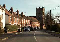 The Street, Ardleigh, with the parish church of St Mary The Virgin and the post office in the background. |
|
 Ardleigh |
|
| Population | c. 2100 |
|---|---|
| OS grid reference | TM052295 |
| – London | 55 mi (89 km) NE |
| Civil parish | Ardleigh |
| District | Tendring |
| Shire county | Essex |
| Region | East |
| Country | England |
| Sovereign state | United Kingdom |
| Post town | COLCHESTER |
| Postcode district | CO7 |
| Dialling code | 01206 |
| Police | Essex |
| Fire | Essex |
| Ambulance | East of England |
| EU Parliament | East of England |
| UK Parliament | Harwich and North Essex |
Coordinates: 51°55′37″N 0°58′59″E / 51.9269°N 0.9831°E
Ardleigh /ˈɑrdli/ is a village and civil parish in Essex, England. It is situated approximately 4 miles (6 km) northeast from the centre of Colchester and 26 miles (42 km) northeast from the county town of Chelmsford.
Ardleigh is in the district of Tendring and the parliamentary constituency of Harwich and North Essex. The village has its own Parish Council.[1] The parish had a population of 2081 according to the 2001 census[2] and includes the area known as Crockleford Heath.
The Great Eastern Main Line passes close to the village but the railway station closed in November 1967. The closest railway station is now at Manningtree, 3 miles (5 km) northeast. The village is on the A137 road, a route from Colchester to Ipswich, Suffolk.
Ardleigh Reservoir is less than 1 mile (1.6 km) to the southwest.
The area includes a number of smallholdings founded by the Land Settlement Association.[3]
References
- ↑ "Town and Parish Council and Clerks Details". Tendring District Council. Retrieved 23 January 2007.
- ↑ "2001 Census: Key Statistics > Parish Headcounts > Area: Ardleigh CP (Parish)". Office for National Statistics. Retrieved 1 June 2010.
- ↑ Bercaw, Louise Oldham; "Bibliography on Land Utilization 1918-36"; p. 1011
External links
 Media related to Ardleigh at Wikimedia Commons
- Ardleigh in the Domesday Book
- "St Mary The Virgin's Church, Ardleigh", Essex Churches
- "Ardleigh's Past", Ancestry.com, Free Pages