Arctic Norway
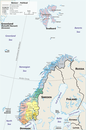
Arctic Norway is a general term comprising the northernmost parts of Norway, more specific above the Arctic circle. Norway, being one of the long-stretched countries in the world, reaches from approx. 58°N to 81°N, and by that large parts lie north of the Arctic circle at 66°33′.
Arctic Norway is constituted of four geographically separated parts:
- Mainland Norway, from 66°33′ to 71°11'N;
- Svalbard, located from 76°28 to 80°49' N;
- Bjørnøya, situated at 74°31′N 19°01′E;
- Jan Mayen, situated at 70°59′N 8°32′W.
The Arctic circle crosses mainland Norway at Saltfjellet, which separates Helgeland from the northern part of Nordland county. By that, about half of the county lies north of the Arctic circle, along with the whole of Troms and Finnmark counties. The total area of mainland Norway above the Arctic circle is ca. 95,000 km2 (37,000 sq mi). The population is about 393,000, which makes this the most populated arctic region in the world.
Svalbard archipelago is situated some 640 km (400 mi) north of mainland Norway and has an area of 61,000 km2 (24,000 sq mi). The population is about 2,400, and includes Longyearbyen, the northernmost town in the world.
Bear Island (Norwegian: Bjørnøya) is situated some 400 km north of mainland Norway, about two thirds the distance to Svalbard. It has an area of 178 km2 (69 sq mi). The population is 9, which is the staff of the weather station.
Jan Mayen is situated some 880 km northwest of mainland Norway and about 450 km off the coast of Greenland. It has an area of 373 km2. The population is 18, which is the staff of the weather station.
All parts of Arctic Norway belong to the Kingdom of Norway. They sent an expedition in 1996 and then late in November 27, 2007