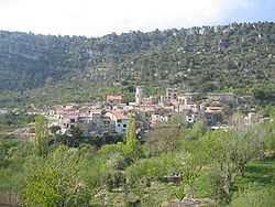
Arbolí
Arbolí | |
---|---|
Municipality | |
![]() | |
![]() ![]() Arbolí Location in Catalonia | |
Coordinates: 41°14′N 0°56′E / 41.233°N 0.933°ECoordinates: 41°14′N 0°56′E / 41.233°N 0.933°E | |
Country |
![]() |
Community |
![]() |
Province | Tarragona |
Comarca | Baix Camp |
Government | |
• Mayor | Jordi Juncosa i Alberich |
Area | |
• Total | 20.77 km2 (8.02 sq mi) |
Elevation | 714 m (2,343 ft) |
Population (2007) | |
• Total | 113 |
• Density | 5.4/km2 (14/sq mi) |
Demonym | Arbolinenc, arbolinenca |
Time zone | CET (UTC+1) |
• Summer (DST) | CEST (UTC+2) |
Arbolí is a municipality in the comarca of the Baix Camp in Catalonia, Spain. It is situated in the west of the comarca in the Prades mountains. A local road links the village with the C-242 road.
The Prades Mountains are located in the vicinity of this municipality.
Demography
1900 | 1930 | 1950 | 1970 | 1986 | 2007 |
---|---|---|---|---|---|
515 | 286 | 169 | 164 | 130 | 113 |
Note
- ^ Arbolí became part of the Baix Camp in the comarcal revision of 1990: previously it formed part of the Priorat.
References
- Panareda Clopés, Josep Maria; Rios Calvet, Jaume; Rabella Vives, Josep Maria (1989). Guia de Catalunya, Barcelona:Caixa de Catalunya. ISBN 84-87135-01-3 (Spanish). ISBN 84-87135-02-1 (Catalan).
External links
- Official website (Catalan)
- Information - Generalitat de Catalunya (Catalan)
- Statistical information - Institut d'Estadística de Catalunya (Catalan)
![]() |
Cornudella de Montsant | La Febró | ![]() | |
|
Vilaplana | |||
| ||||
| ||||
Alforja |
|