Arani Municipality
| Arani Municipality | |
|---|---|
| Municipality | |
|
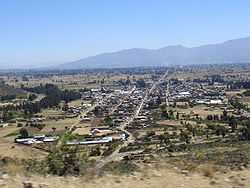
Arani | |
 Arani Municipality Location of the Arani Municipality within Bolivia | |
| Coordinates: 17°34′0″S 65°46′0″W / 17.56667°S 65.76667°WCoordinates: 17°34′0″S 65°46′0″W / 17.56667°S 65.76667°W | |
| Country |
|
| Department | Cochabamba Department |
| Province | Arani Province |
| Seat | Arani |
| Government | |
| • Mayor | Vicente Rojas Camacho (2007) |
| • President | Ramiro Montaño Orellana (2007) |
| Area | |
| • Total | 83 sq mi (214 km2) |
| Population (2001) | |
| • Total | 11,542 |
| • Ethnicities | Quechuas |
Arani Municipality is the first municipal section of the Arani Province in the Cochabamba Department, Bolivia. Its seat is Arani. At the time of census 2001 the municipality had 11,542 inhabitants.[1]
It is bordered to the north by the Tiraque Province, to the east by the Vacas Municipality, to the south by the Mizque Province and to the west by the Punata Province.
Subdivision
The municipality consists of the following three cantons:
| Canton | Inhabitants (2001)[1] | Seat | Inhabitants (2001) |
|---|---|---|---|
| Arani Canton | 6,978 | Arani / Jarani | 3,512 |
| Collpaciaco Canton[2] | 3,190 | Collpaciaco / Qullpayaku | 246 |
| Pocoata Canton | 1,374 | Pocoata / Puquqwata | 685 |
Population
The people are predominantly indigenous citizens of Quechua descent.[3]
| Ethnic group | % |
|---|---|
| Quechua | 87.2 |
| Aymara | 0.4 |
| Guaraní, Chiquitos, Moxos | 0.2 |
| Not indigenous | 12.1 |
| Other indigenous groups | 0.1 |
Festivities
Every year on August 24 the population of Arani celebrates one of its most important Catholic festivities, Virgen La Bella, dedicated to the Virgin Mary, whose image is venerated with much devotion by the residents and people from abroad.
-
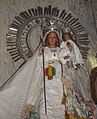
Virgen María La Bella
-
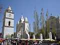
San Bartolomé church in Arani which keeps the shrine of the Virgen La Bella
See also
References
- ↑ 1.0 1.1 Instituto Nacional de Estadística
- ↑ Arani - Gobierno Autonomo Municipal (Spanish)
- ↑ obd.descentralizacion.gov.bo/municipal/fichas/ (inactive)
