Aral, Kazakhstan
| Aral Арал | |
|---|---|
 | |
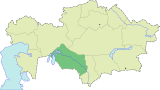
 Aral Location in Kazakhstan | |
| Coordinates: 46°47′0″N 61°40′0″E / 46.78333°N 61.66667°E | |
| Country |
|
| Region | Kyzylorda |
| Population (2009)[1] | |
| • Total | 29,987 |


Aral, also known as Aralsk or Aral'sk, (Kazakh: Арал, Russian: Аральск) Coordinates: 46°47′N 61°40′E / 46.783°N 61.667°E is a small city in south-western Kazakhstan, located in the oblast (region) of Kyzylorda. It serves as the administrative center of Aral District. Aral was formerly a fishing port and harbour city on the banks of the Aral Sea, and was a major supplier of fish to the neighboring region. Population: 29,987 (2009 Census results);[1] 30,347 (1999 Census results).[1]
History
Early settlement
Close to current Aralsk since 1817 there was a village Alty-Kuduk (6 wells) - at present this is a railway passing-track in the southern part of the city. Since 1870s it was recorded as Aralsky settlement. The development of Aralsk began when Orenburg-Tashkent railway was being constructed (1899-1905). In 1905 the railway station was constructed (it still operates), official history of Aralsk began that very year.
In 1905 Russian merchants organized large fishing companies and formed a joint-stock firm in Aralsk, it was the start of fishery in the Aral. It was the time when ship-building plants were formed in Aralsk.
After Revolution the station “Aralskoye more (sea)” with the adjoining settlement received the name Aralsk. Since 1938 Aralsk together with Aralsky district became a part of newly formed Kzyl-Orda oblast of Kazakh SSR and turned into the town.
Decline
Since the retreat of the Aral Sea since 1960, due to diversion of the rivers flowing into it for irrigation, mainly of cotton, during the Soviet era, Aral is now completely landlocked about 12 km from the northern remnant of the Aral Sea, though this is less than the 100 km distance observed before the completion of a dam in 2005. Aral has greatly diminished in population and socioeconomic significance, resulting in high levels of unemployment. For the last 25 years it has not been possible to see the sea from the town. There are also serious health problems for the local population caused by airborne toxic chemicals exposed to the wind by the retreating waters and, possibly, from chemical and biological agents unsafely stored on the island of Vozrozhdeniya.
Aral smallpox incident
In 1971, a massive public health response to a smallpox outbreak in Aral ensued once the disease was recognized as resulting from release of weaponized smallpox from a nearby biological weapons test site. In less than 2 weeks, approximately 50,000 residents of Aral were vaccinated. Household quarantine of potentially exposed individuals was enacted, and hundreds were isolated in a makeshift facility at the edge of the city. All traffic in and out of the city was stopped, and approximately 54,000 square feet of living space and 18 metric tons of household goods were decontaminated by health officials. The original outbreak sickened ten people in Aral, of whom 3 died.[2]
Climate
Aral has a cold desert climate (Köppen climate classification BWk) with cold winters and hot summers.
| Climate data for Aral | |||||||||||||
|---|---|---|---|---|---|---|---|---|---|---|---|---|---|
| Month | Jan | Feb | Mar | Apr | May | Jun | Jul | Aug | Sep | Oct | Nov | Dec | Year |
| Record high °C (°F) | 6.3 (43.3) |
17.8 (64) |
29.2 (84.6) |
33.9 (93) |
39.9 (103.8) |
46.9 (116.4) |
44.8 (112.6) |
44.4 (111.9) |
41.0 (105.8) |
32.6 (90.7) |
24.7 (76.5) |
10.3 (50.5) |
46.9 (116.4) |
| Average high °C (°F) | −6.6 (20.1) |
−5.1 (22.8) |
3.7 (38.7) |
17.7 (63.9) |
25.7 (78.3) |
32.3 (90.1) |
34.2 (93.6) |
32.4 (90.3) |
25.2 (77.4) |
15.4 (59.7) |
4.1 (39.4) |
−3.7 (25.3) |
14.6 (58.3) |
| Daily mean °C (°F) | −10.6 (12.9) |
−9.6 (14.7) |
−1.4 (29.5) |
11.2 (52.2) |
18.9 (66) |
25.5 (77.9) |
27.6 (81.7) |
25.5 (77.9) |
18.0 (64.4) |
8.9 (48) |
−0.4 (31.3) |
−7.6 (18.3) |
8.8 (47.8) |
| Average low °C (°F) | −14.4 (6.1) |
−13.6 (7.5) |
−5.6 (21.9) |
5.2 (41.4) |
12.1 (53.8) |
18.2 (64.8) |
20.5 (68.9) |
18.3 (64.9) |
11.1 (52) |
3.2 (37.8) |
−4.0 (24.8) |
−11.0 (12.2) |
3.3 (37.9) |
| Record low °C (°F) | −37.9 (−36.2) |
−37.2 (−35) |
−36.1 (−33) |
−15.9 (3.4) |
−5.4 (22.3) |
3.6 (38.5) |
8.2 (46.8) |
5.4 (41.7) |
−4.4 (24.1) |
−15.7 (3.7) |
−31.6 (−24.9) |
−34.8 (−30.6) |
−37.9 (−36.2) |
| Average precipitation mm (inches) | 12 (0.47) |
10 (0.39) |
15 (0.59) |
12 (0.47) |
15 (0.59) |
15 (0.59) |
8 (0.31) |
5 (0.2) |
6 (0.24) |
12 (0.47) |
13 (0.51) |
12 (0.47) |
135 (5.31) |
| Avg. rainy days | 4 | 4 | 6 | 8 | 10 | 7 | 8 | 5 | 5 | 7 | 7 | 5 | 76 |
| Avg. snowy days | 16 | 12 | 7 | 1 | 0 | 0 | 0 | 0 | 0 | 1 | 5 | 13 | 55 |
| Average relative humidity (%) | 84 | 82 | 76 | 53 | 45 | 37 | 37 | 37 | 43 | 58 | 76 | 82 | 59 |
| Source: Pogoda.ru.net [3] | |||||||||||||
References
- ↑ 1.0 1.1 1.2 "Население Республики Казахстан" (in Russian). Департамент социальной и демографической статистики. Retrieved 8 December 2013.
- ↑ Zelicoff, A.P., “An epidemiological analysis of the 1971 smallpox outbreak in Aralsk, Kazakhstan” (2002), In: Tucker, J.B. and R.A. Zilinskas,eds., The 1971 Smallpox Epidemic in Aralsk, Kazakhstan, and the Soviet Biological Warfare Program; Monterey, California: Monterey Institute of International Studies, Center for Nonproliferation Studies. Occasional Paper No. 9.
- ↑ "Weather and Climate- The Climate of Aral" (in Russian). Weather and Climate (Погода и климат). Retrieved November 16, 2012.
Further reading
- Bissell, Tom (2003). Chasing the Sea: Lost Among the Ghosts of Empire in Central Asia. New York: Pantheon Books. ISBN 0-375-42130-0.
External links
![]() Media related to Aral (city) at Wikimedia Commons
Media related to Aral (city) at Wikimedia Commons
- News story on the plight of Aralsk and the Aral Sea.
- The shrinking Aral Sea.
- Bringing life back to Asia's 'dead' sea.
| |||||||||||||||||