Arai Station (Niigata)
Arai Station 新井駅 | |
 | |
|---|---|
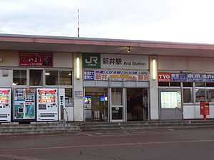
| The station in JR East days, November 2013 | |
| Location | |
| Prefecture | Niigata (See other stations in Niigata) |
| City | Myōkō |
| History | |
| Year opened | 1886 |
| Rail services | |
| Operator(s) | Echigo Tokimeki Railway |
| Line(s) | Myōkō Haneuma Line |
Arai Station (新井駅 Arai-eki) is a railway station on the Echigo Tokimeki Railway Myōkō Haneuma Line in Myōkō, Niigata, Japan, operated by the third-sector railway operator Echigo Tokimeki Railway.
Lines
Arai Station is served by the 37.7 km Echigo Tokimeki Railway Myōkō Haneuma Line from Myōkō-Kōgen to Naoetsu. Two return Shirayuki limited express services and two limited-stop "Rapid" services operate daily between Arai and Niigata.
Adjacent stations
| « | Service | » | ||
|---|---|---|---|---|
| Echigo Tokimeki Railway Myōkō Haneuma Line | ||||
| Terminus | Shirayuki | Jōetsumyōkō | ||
| Terminus | Rapid | Kita-Arai | ||
| Nihongi | Local | Kita-Arai | ||
History
Arai Station opened on 15 August 1886.[1] With the privatization of JNR on 1 April 1987, the station came under the control of JR East.[1]
From 14 March 2015, with the opening of the Hokuriku Shinkansen extension from Nagano to Kanazawa, local passenger operations over sections of the Shinetsu Main Line and Hokuriku Main Line running roughly parallel to the new shinkansen line were reassigned to third-sector railway operating companies.[2] From this date, Arai Station was transferred to the ownership of the third-sector operating company Echigo Tokimeki Railway.
References
- ↑ 1.0 1.1 Ishino, Tetsu, ed. (1998). 停車場変遷大辞典 国鉄・JR編 [Station Transition Directory - JNR/JR] II. Japan: JTB. p. 582. ISBN 4-533-02980-9.
- ↑ Osano, Kagetoshi (March 2015). 北陸新幹線並行在来線各社の姿 [Guide to companies operating conventional lines alongside the Hokuriku Shinkansen]. Tetsudō Daiya Jōhō Magazine (in Japanese) (Japan: Kōtsū Shimbun) 44 (371): p.28-33.
External links
| Wikimedia Commons has media related to Arai Station (Niigata). |
- Echigo Tokimeki Railway station information (Japanese)
| ||||||
Coordinates: 37°01′36″N 138°15′20″E / 37.02667°N 138.25556°E