Aragatsotn Province
| Aragatsotn Արագածոտն | |
|---|---|
| Province | |
 Location of Aragatsotn within Armenia | |
| Coordinates: 40°25′N 44°10′E / 40.417°N 44.167°ECoordinates: 40°25′N 44°10′E / 40.417°N 44.167°E | |
| Country | Armenia |
| Capital | Ashtarak |
| Government | |
| • Governor | Sargis Sahakyan |
| Area | |
| • Total | 2,756 km2 (1,064 sq mi) |
| Area rank | 5th |
| Population (2011) | |
| • Total | 132,925 |
| • Rank | 9th |
| • Density | 48/km2 (120/sq mi) |
| Time zone | UTC+04 |
| Postal code | 0201-0514 |
| ISO 3166 code | AM.AG |
| FIPS 10-4 | AM01 |
| Website | aragatsotn.gov.am |
| Part of a series on |
| Armenia Հայաստան |
|---|
  |
| Culture |
| History |
| Demographics |
| Administrative divisions |
|
| Armenia portal |
Aragatsotn (Armenian: Արագածոտն, Armenian pronunciation: [ɑɾɑɡɑˈt͡sɔtən]) is a province (marz) of Armenia. It is in the west of the country, and its capital is Ashtarak. The name means "a foot of Aragats" (the highest mountain of the Republic of Armenia). During the Arsacid Dynasty of the Kingdom of Armenia, the region was part of the Ayrarat province. It was ruled by the Amatuni noble family with its capital at Oshakan.
The region is primarily inhabited by Armenians but also holds a significant Yazidi Kurdish minority.
Aragatsotn's western edge forms part of Armenia's border with Turkey. It also borders the following marzer:
Aragatsotn also shares a small border with Yerevan in its southwest between its borders with Kotayk and Armavir.
Communities
The province of Aragatsotn consists of the following 114 communities (hamaynkner), of which 3 are considered urban and 111 are considered rural.[1]
Towns or urban communities
| Image | City (town) | Region | Founded | Land area (km2) | Population (2011 est.) |
|---|---|---|---|---|---|
 | Aparan | Aragatsotn | 2nd century (first mentioned) | 3.5 | 6,700 |
 | Ashtarak | Aragatsotn | 9th century (first mentioned) | 7.5 | 20,800 |
 | Talin | Aragatsotn | 2nd century (first mentioned) | 7 | 5,700 |
Villages or rural communities
Non-community villages
- Dzoragyugh, belongs to the Mastara community.
- Karin, belongs to the Sasunik community.
- Khnusik, belongs to the Avan community.
- Lusaghbyur, belongs to the Artashavan community.
- Mughni, belongs to the Ashtarak community.
- Nigatun, belongs to the Artashavan community.
- Aragatsotn
-

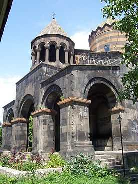
Cathedral of Talin, 7th century
-

Saghmosavank Monastery, 13th century
-
Saint Gevorg Monastery of Mughni, 14th century
-
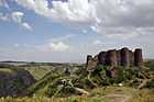
Amberd fortress and Vahramashen Church
-

Armenian alphabet park near Aparan
See also
Notes
- ↑ "RA Aragatsotn Marz" (PDF). Marzes of the Republic of Armenia in Figures, 2002–2006. National Statistical Service of the Republic of Armenia. 2007.
References
- Report of the results of the 2001 Armenian Census, National Statistical Service of the Republic of Armenia
External links
| ||||||||||||